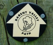
Darent Valley Path Marker
DARENT VALLEY PATH
Sevenoaks to Dartford
|
|
Darent Valley Path Marker |
I did this walk on 3rd June 2006 and it was definitely one of my most enjoyable walks so far this year, passing through some stunning countryside. The weather was perfect for walking, finally dry bright and sunny without a cloud in the sky and nice and warm without being too hot. Far better than a couple of weeks ago when I had originally intended to do this walk. I was up reasonably early and was in Sevenoaks at the start of the walk not long after nine o'clock. The path is reasonably well waymarked although these are sometimes quite far apart and I did need to stop and refer to my map on a couple of occasions
 |
 |
 |
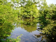
(1) Ponds, Sevenoaks |
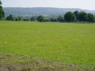
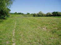
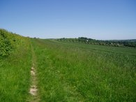
(2) View towards the North Downs |
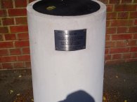
(3) Planet Pillar, Otford |
The walk starts off from Sevenoaks Station with a stretch of road walking, going down Hitchen Hatch Road for a short distance then taking the first left into Bradbourne Park Road. This is followed as far as the unsurfaced Clock House Lane where the path once again turns left, crossing a bridge over the railway lines before turning right into Lambarde Road. A short distance along Lambarde Road the path enter a park with a number of lakes which is followed across Betenson Avenue to Bradbourne Vale where the path follows the busy A25 for a short distance before turning onto a track the runs down besides the Sevenoaks Wildfowl Reserve although this is almost completely hidden by the trees lining the path with only the occasional hint of the West Lake behind them. The path continues along a rather dull track past an industrial estate on the left before eventually exiting the trees into open fields with glorious views of the North Downs in the distance, photo 2.
The path then goes along a minor road for a short distance before turning left to take a path across a field and over another railway line. The path then follows the course of the railway under the M26 and besides fields till a turning on the right leads once again over the railway lines.
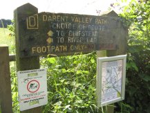 |
(2a) Darent Valley Path sign |
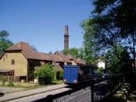
There are two arms of the Darent Valley path at this end of the walk, one running from Sevenoaks, (which I had taken), and one running from Chipstead, and this is the point where the two paths meet up. The route also joins up with the North Downs Way at this point and photo 2a was taken during my walk along the North downs Way in 2008. Some how I had missed the sign the first time around!
Once over the railway lines the route joins a track that leads into the village of Otford. Passing through Otford I noticed the pillar in photo 3. The plaque says that "This pillar is part of the Earth's largest solar system scale model (1:5 billion) showing the planet positions at 00:01 hours 1 Jan 2000. Sun is 981 meters away on the recreation ground". The pillar in the photo represented Neptune. I never got to the sun but I did pass another planet, Saturn I think, as I made my way through the village.
 |
 |
 |
(4) Darent Valley Path, Nr Otford |
(5) Darent Valley Path, approaching Shoreham |
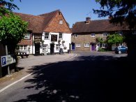
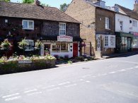
(6) Ye Olde George Inne, Shoreham |
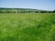
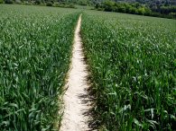
From Otford the River Darent Path follows the river for a short distance before heading across fields in the broad valley the River Darent has carved through the North Downs. The views along this part of the path were, whilst not dramatic, still quite stunning. The path leaves the fields to pass through the Darent Valley Golf Course from where it makes its way down to a short stretch of road walking through the village of Shoreham, photo 6.
 |
 |
 |
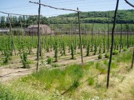
(7) Hop farm |
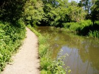
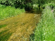
(8) River Darent |
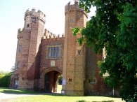
(9) Gatehouse, Lullingstone Castle |
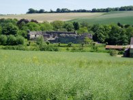
Once again the path follows the river as it leaves the village before moving away from the bank and crossing more fields, including one where some hops had been planted, photo 7. Another short stretch of road walking leads to the car park and information centre at Lullingstone Park where the river is rejoined, photo 8, as the Darent Valley path makes its way past the entrance to Lullingstone Castle, photo 9. Lullingstone Castle is more of a country house than a traditional castle and the current manor house and gatehouse in the photo where built in 1497.
 |
 |
 |
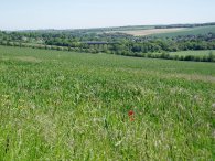
(10) Fields nr Eynsford |
(11) Fields nr Eynsford |
(12) Fields nr Eynsford |
Not far past Lullingstone Castle the path leaves the course of the River Darent and climbs up the side of the valley beside a field, photo 10, gaining about 50 mts in height. The path then runs along the top edge of the field, photo 11, with excellent views down to the right over the Darent Valley before descending once again through more fields, photo 12, and crossing a railway line to join a road on the outskirts of the village of Eynsford.
 |
 |
 |
(13) Poppies |
(14) Eynsford Castle |
(15) Farningham |
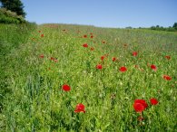
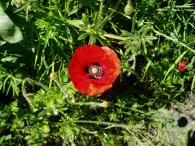
In a number of the fields there were a considerable number of poppies growing amongst the crops, photo 13. From Eynsford the Darent Valley Path follows the road towards Farningham. On my map the path was marked as going along the road but a permissive path has been made in the fields that run alongside to the right of the road which avoids any road walking having to be done. From the path the ruins of Eynsford Castle could be seen down to the right, photo 14. Reaching Farningham, photo 15, the path turns right along the road before turning left besides a pub next to the river.
 |
 |
 |
(16) River Darent |
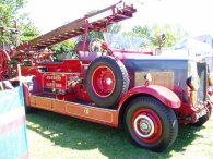
(17) Old Fire Engine |
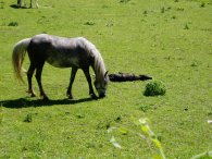
(18) New born foal |
The Darent Valley Path then follows the river, photo 16, as it passes under the A20 and then the M20 in quick succession before continuing on to Horton Kirby, (which sounds as if should be somewhere in the Lake District). in Horton Kirby they were holding their village fete, the path running through the recreation ground where it was being held. This was an unexpected and pleasant diversion. As well as the old fire engine in photo 17 there were lots of other stalls and displays to look round including one with birds of prey. The path continues alongside the river till a road is reached opposite the rail viaduct that leads to Farningham Road station. Lying down in a field besides the road was a new born foal which is next to horse in photo 18. According to a passerby, it had been born that morning.
 |
 |
 |
(19) South Darenth |
(20) Fields Nr South Darenth |
(21) Poppy |
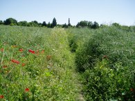
The path turns right along Station Road, road parallel with the rail viaduct for a short distance before coming to a T junction where the path turns left along Horton Road and heads under the rail bridge through South Darenth, photo 19. This runs into Holmesdale Road before the Darent Valley Path heads off once again over fields to the left. Photo 20 was taken looking back to South Darenth and in the fields there were yet more poppies, something I haven't seem much recently hence another photo, 21.
 |
 |
 |
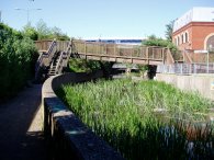
(22) Dartford |
(23) Approaching Dartford Station |
(24) Darent Valley Path route marker |
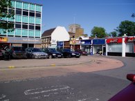
The landscape in this area started to get more suburban and built up as the path made its approach to Dartford and I did not take any photos for the next couple of miles until I reached Dartford. The Darent Valley Path itself crosses Parsonage Lane and goes long Darenth Road before taking a path off to the left that leads under the M25 and up to the A225. There then follows a bit of road walking as the path goes under the A2 before heading diagonally across a field to rejoin the River Darent. The route of the path here was a bit unclear and not marked on the map. The path then makes its way alongside an industrial estate before passing alongside Brooklands Lake before climbing up hill to cross the A225 again. The path is supposed to go straight across the road into Central Park but access on the other side was blocked due to work on the riverbank and thus I had to turn left down the main road and work my way round to another entrance into the park to rejoin the official route of the path. The note on the gate stated that "This gate will be closed from Monday 16 January 2006 until further notice due to River Darent de-silting works. It is anticipated it will be re-opened at the end of February". Considering it was now mid June the works had considerably over run and perhaps an up to date notice would have been in order along with a signed diversion for Darent Valley Path walkers. Central Park was packed with people in the bright afternoon sunshine as I made my way towards the centre of Dartford, photo 22 and on to the station, photo 23. At several points tile route markers had been placed in the pavement, photo 24, making the route of the path relatively easy to follow as it goes through Dartford.
The GPS made this walk 15.8 miles long. The walk can easily be shortened by ending at Farningham Road Station rather Dartford and little of scenic interest would be missed by ending the walk at this point. There is also a continuation of the Darent Valley Path from Dartford down to the River Thames which is covered as part of my walk from Crayford to Northfleet although the nearest convenient public transport to the end of the walk is back at Dartford.
![]() Back to:Walking index page
Back to:Walking index page
| ©2008 Bertuchi.co.uk. Please contact me if you have any questions or comments regarding the site. Additional information about places of interest on the walks is always welcomed. All rights reserved. Please contact me if you want to use any of the images or information from the site. Thank you. |
|