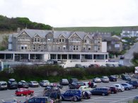
(1) Watergate Bay Hotel
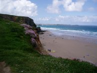
(2) Watergate Bay, looking South
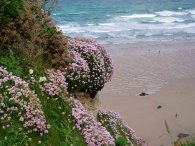
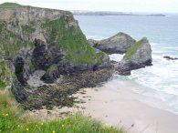
(3) Thrift, Watergate Bay
WATERGATE BAY TO THE RIVER GANNEL
I did this walk on 29th May 2006. The day was very windy and also started quite cloudy but as can be seen from the photo's it soon brightened up.|
|
|
|
(1) Watergate Bay Hotel |
(2) Watergate Bay, looking South |
(3) Thrift, Watergate Bay |
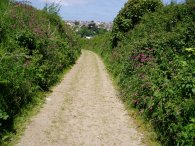
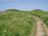
I parked in the rather expensive car park opposite the Watergate Bay hotel, photo 1, and turned and headed West down the coast towards Newquay. After the intial climb up from the car park this section of the South West Coast path is relatively flat as it makes its way over the cliffs, high above Watergate Bay, photo's 2 and 3.
 |
 |
 |
(4) Watergate Bay, looking North |
(5) Zacry's Islands |
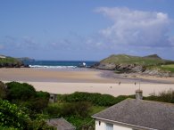
(6) Porth Beach |
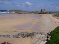
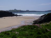
Heading over the cliffs the path passes above Zacry's islands, photo 5, at the far end of Watergate Bay and then makes its way gradually down hill to the beach at Porth, photo 6. From Porth the path heads uphill alongside the road to the outskirts of Newquay.
 |
 |
 |
(7) Lusty Glaze |
(8) Tolcarne Beach |
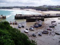
(9) Newquay Harbour |
The path makes its way through Newquay sticking close to the cliff to upon a mixture of footpaths and roads until the town centre is reached. The path passes Lusty Glaze, photo 7 and Tolcarne Beach, photo 8. Lusty Glaze was the proposed terminus of the Edyvean Canal which was started in 1773 but never completed and the remains of an inclined plane that was to link the canal to the sea can still be seen in the cliff. As the path approaches the town centre the path moves inland slightly, first along the route of the old tram tracks and then past shops and houses before descending down a narrow road towards Newquay Harbour, photo 9.
 |
 |
 |
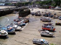
(10) Newquay Harbour |
(11) The Huers Hut |
(12) View towards Trevose Head |
From Newquay Harbour, photo 10, thhe path climbs uphill to a short section of road where the path passes the Huers Hut, photo 11, before heading along a track that leads to Towan Head. According to a plaque on the building the Huers Hut is though to date from the 14th Century and was used as a lookout by a huer at the time of year when shoals of Pilchards were expected in the bay. A call on his horn raised the hue and cry alerting the townsfolk to the arrival of the fish. As the path heads towards Towan Head there are good view back up the coast towards Watergate Bay and on to Trevose Head which can be seen in the distance, photo 12.
 |
 |
 |
(13) Fistral Bay and Towan Head |
(14) Footbridge across the Gannel |
(15) View over the Gannel |
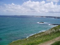
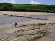
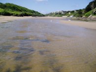
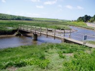
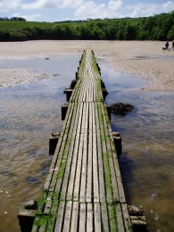
From Towan Head the turns left, past the Headland hotel and goes down to Fistral Beach past the National surfing Centre. The path runs along sand dunes at the back of Fistral Beach, photo13, along a path that was lined with sweet smelling roses. At Pentire I turned left onto the road and then right along a road that led to a footpath that passed downhill through some trees down to the River Gannel. A short walk besides the river led to the tidal footbridge across the Gannel, photo 14, which as it was low tide I had no trouble crossing over to Penpol on the other bank. Photo 15 was taken from the footbridge looking down the Gannel towards the sea.
 |
 |
 |
(16) Field, nr Treringey |
(17) Path from Trevemper |
(18) Footbridge over the Gannel |
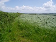
At Penpol I headed up a track towards Little Trevithick and on over fields past the farm at Treringey to Trevemper. On my map this marked as an alternative route for the South West Coast path, I assume for when the summer ferry isn't runing and the tide is too high to use the footbridge at Penpol, however the paths across the fields, photo 16, were quite overgrown and did not seem to be much used at all. At Trevemper I turned left onto a track, photo 17, that eventually made its way back down to the River Gannel and over another footbridge, photo 18, to the outskirts of Newquay.
 |
 |
 |
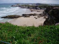
(19) Porth Beach |
(20) Zacry's Islands |
(21) Tumuli nr Watergate Bay |
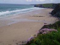
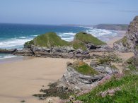
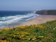
I took a footpath that climbed steeply uphill between houses at Trenance before going along a couple of side roads to Trenance Road and then on to Berry Road and back down to re-join the coast path at Cliff Road amongst the chip shops and amusement arcades of Newquay. From this point I followed the route I had taken earlier back to Watergate Bay. Although retracing my steps this did however give me a different perspect of the views along the coast and the weather was now far brighter. It was still incredibly windy though which is not evident from the pictures. Photo 19 was taken from above Porth beach looking back towards Towan Head. Photo 20 is a view of the other side of Zacry's Islands and photo 21 is of the two burial mounds on top of the cliffs between Porth and Watergate Bay.
 |
 |
 |
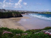
(22) Watergate Bay |
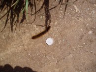
(23) Caterpillar |
(24) Watergate Bay Hotel |
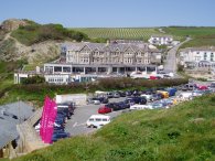
Photo 22 is another view of Watergate Bay and photo 23 shows a large caterpillar crossing the path, one of many I saw out on the walk. I put a 10p piece besides the caterpillar to give some indication of how long it was. I'm not sure what type of caterpillar it is though. The final photo is another view of the Watergate Bay Hotel where I have stayed a number of times in the past when the kids were younger. The purple flags in the foreground mark the entrance to Jamie Olivers new "Fifteen Cornwall" restuarant that had just opened.
As a test I have added a slideshow of larger versions of these photos which can be found at Newquay Slideshow. This is hosted on Dani's website. It still needs a fair bit of work to customise the layout as I want, the current display is as it came, and I will be gradually improving it with things like a back button to my site. See what you think!
 |
(25) Footbridge over the Gannel |
The GPS made this walk 12.5 miles long.
![]() Back to:Walking index page
Back to:Walking index page
| ©2008 Bertuchi.co.uk. Please contact me if you have any questions or comments regarding the site. Additional information about places of interest on the walks is always welcomed. All rights reserved. Please contact me if you want to use any of the images or information from the site. Thank you. |
|