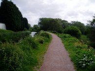
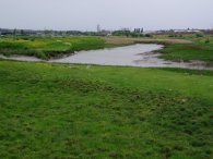
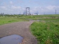
(1) River Cray
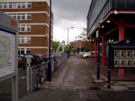
(2) Dartford Station
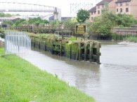
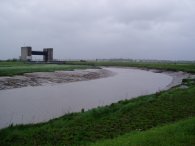
(3) River Darent, Dartford
CRAYFORD TO NORTHFLEET
I did this walk on 22 May 2006. I had a couple of days off work and my original plan was to walk down the Darent Valley path from Sevenoaks to Dartford however despite it being the end of May the weather forecast was terrible and thus it seemed sensible to save what should be a very pleasant walk through the Kent countryside to a time when the weather would be better. As a last minute alternative I decided to do this walk from Crayford with Gravesend as my intended destination, the weather more suiting to the mainly industrial landscape I would be passing through.
|
|
|
|
(1) River Cray |
(2) Dartford Station |
(3) River Darent, Dartford |
The day started well as I drove to Crayford station and was able to park in the last available parking place. From Crayford station I crossed Station Road and took a footpath besides the tracks that leads to Crayford Road. I turned right along Crayford Road, past the sign marking, the boundary between London and Kent and then turned left down Maiden Lane to join the River Cray and the Cray Riverway, photo 1, for a short distance on its way to the A206. This short section of walk is also part of the London Loop which I had walked a few weeks previously. I then followed the A206 for a short distance before turning up a track besides a railway bridge. This gradually petered out and I had to make my own way over a rather muddy ditch before taking a selection of footpaths and tracks that led past houses towards the centre of Dartford, eventually reaching Kingsfield Road from where it was a short walk under the rail bridge to Victoria Road. I paid a quick visit to Dartford Station, photo 2, before heading down Hythe Street where I joined the Darent Valley path on its way to the Thames. From Hythe Street the path turns right down besides the Phoenix pub on a track that leads down to a bridge over the River Darent. From this point the River Darent is followed all the way to the Thames. There were a number of old locks on the river near Dartford, photo 3, although these were all in a state of disrepair.
 |
 |
 |
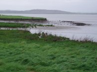
(4) Dartford Marshes |
(5) Crayford Creek |
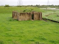
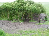
(6) Dartford Marshes |
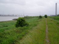
The next three photo's, 4, 5 and 6 were taken from besides the River Darent as it makes its way over Dartford Marshes to the Thames. The path meanders besides the creek along the top of the flood wall, Photo 5 shows the junction of the River Darent and Crayford Creek. There was a very strong wind blowing across the marshes which made walking quite difficult in places and as I continued it started raining, at first quite lightly but it soon got steadily heavier and heavier. I put my waterproof jacket on but was trying to avoid having to wear my overtrousers. With the wind blowing so strongly I thought the rain might blow over quickly and for a while I sheltered under the small stand of trees shown in photo 6. They were in the lea of the flood wall and remained quite dry, on a less windy day they would have provided far less shelter than they did. Eventually it became evident that the rain was not going to blow over so I put my full waterproof kit on and headed off through the rain.
 |
 |
 |
(7) Dartford Creek |
(8) River Darent meets the Thames |
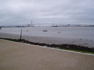
(9)View towards the QEII bridge |
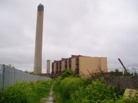
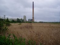
The path makes it way past the flood barrier, photo 6, down to the Thames, photo 7, which marks the end of the Darent Valley path. I then turned East and began a fairly straight walk down the Thames Estuary. The skyline in front of me being dominated by the Queen Elizabeth II Bridge at Dartford along with dominant landmark of the tower of the nearby Littlebrook Power Station.
 |
 |
 |
(10) Approaching the QEII Bridge |
(11) Littlebrook Power Station |
(12) The Melusine |
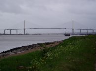
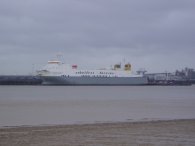
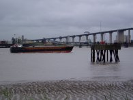
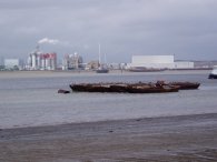
This was a fairly desolate section of path with little of interest apart from the ever increasing size of the QEII bridge, photo 10, and the Littlebrook Power Station, photo 11. There was quite a lot of boat traffic on the River and photo 12 is of the Cobelfret Ferries "Melusine", a 162m boat built in Japan in 1999 by Kawasaki Heavy Industries Ltd. As I approached the bridge the rain finally began to ease off although the weather still remained quite grey and windy.
 |
 |
 |
(13)The QEII Bridge, Dartford |
(14) The QEII Bridge, Dartford |
(15) The Britta Oden |
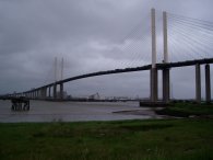
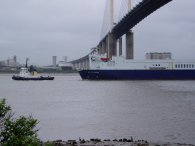
The Queen Elizabeth II Bridge, photo 14, was built to expand crossing capacity between sections of the M25 motorway. The central span is 450 m long and is suspended 65 m above the Thames. When it was opened on the 30 October 1991, it was Europe's largest cable-supported bridge. The approach viaducts on the Essex side measure 1052 m, and 1008 m on the Kent side, giving the total length of 2872 m. It is an impressive structure and one I had driven over many times in the past, now I was able to get a close up view from a very different perspective. As I was looking at the bridge a ship, the Britta Oden, photo 15, passed underneath towed by a tug. Once I had passed under the bridge I continued heading down river alongside the Thames towards Stone. This is an area which is undergoing re-development and after a while I had to leave the Thames and follow the A206 for a short distance before turning left down Station Road besides an Asda supermarket and then right to pass through a residential area at Greenhithe, crossing a road called the Avenue and heading along a short footpath into the grounds around Ingress Abbey.
 |
 |
 |
(16) Ingress Abbey |
(17) River Thames |
(18) Ingress Park |
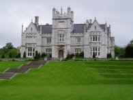
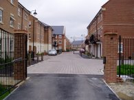
Apart form the Abbey itself, photo 16, this is marked on my map as the location of the Thames Nautical Training College and on a more recent map, College Mills. What confronted me however was a large new housing estate, Ingress Park, that was still in the process of being built. Whilst the map showed a footpath directly across the site this had been subsumed by the new housing. However at first all went well, I stopped on a bench below the Abbey and took off my waterproofs, had a sandwich and then wandered down between houses to the Thames where I took photo 17, looking back up towards the QEII bridge. Besides the river there was a small plaque to the training ship HMS Worcester that had been moored at the site between 1871 and 1978.
It did not appear possible to continue down the Thames because not much further down was a building site that appeared boarded off from public access. I then began trying to find an alternative route through the housing, photo 18, however which ever way I turned I always ended up at a dead end. After wandering around in circles through the houses for the best part of half and hour I eventually had to admit defeat and headed back out along the main road into the development which climbed uphill to the A226.
 |
 |
 |
(19) Ingress Park |
(20) River Thames |
(21) Swanscombe Marshes |
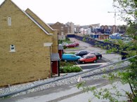
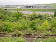
I followed the A226 for a short distance before heading down a footpath to the left that ultimately led back down beside the housing development at Ingress Park, photo 19, and on to the Thames. I had walked around the houses shown in photo 19 but there had been no way to climb up the slope and over the fence that separated the path from the houses. (And also at that stage I didn't know that there was a path at the top of the hill either). The whole episode had been a rather frustrating waste of time and once I reached the Thames, looking back, it appeared that there might have been a path alongside the river that I could have used after all. For me though it was time to push on over Swanscombe Marshes. Although a footpath is marked on the map this was rather vague on the ground. Following the line of some Electricity pylons helped ensure I was heading in the right direction but it was not straight forward walking as I made my way to past Botany Marshes to Manor Way.
 |
 |
 |
(22) Botany Marshes |
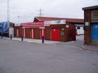
(23) Gravesend and Northfleet FC |
(24) Ebbsfleet International Station |
Manor Way was a busy industrial road however for most of its length the footpath ran along the top of hedge lined embankment up above the road which was reasonably pleasant to walk along. Up until I had reached Ingress Park I had been making very good time on the walk, despite the poor weather however the last couple of miles had taken ages and when I reached the main road by the Gravesend and Northfleet football ground , photo 23, I decided, after some debate, to cut short my walk and head home from Northfleet station rather than continue on into Gravesend. It was annoying having to make this decision and not complete my plans but in the circumstances it was the sensible choice. Northfleet Station itself was rather run down with no train indicator boards however I did not have to wait too long before a train turned up to take me back to the car at Crayford. From the back of the station the new Ebbsfleet International Station on the Channel Tunnel rail link was clearly visible, photo 24, looking very different from the station I was waiting at.
At the end of the day this had been an enjoyable walk as far as Ingress Abbey but things had gone a bit downhill from there on what should have been a very straight forward walk however these things happen occasionally.
The GPS made this walk 14.3 miles long.
![]() Back to:Walking index page
Back to:Walking index page
| ©2008 Bertuchi.co.uk. Please contact me if you have any questions or comments regarding the site. Additional information about places of interest on the walks is always welcomed. All rights reserved. Please contact me if you want to use any of the images or information from the site. Thank you. |
|