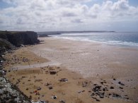
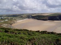
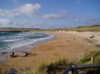
(1) Watergate Bay
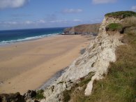
(2) Watergate Bay
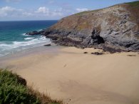
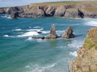
(3) Beacon Cove
WATERGATE BAY TO CONSTANTINE BAY
I did this walk on 12th August 2006 during a very brief trip down to Cornwall. I had driven down from London in the morning and was able to set out walking from Watergate Bay around 3:30pm. This was a straight forward walk along the South West Coast Path in reasonably fine weather although there was a very strong wind blowing in off the sea.
|
|
|
|
(1) Watergate Bay |
(2) Watergate Bay |
(3) Beacon Cove |
My father very kindly dropped me off at the car park by the Watergate Bay Hotel where I had finished my walk on 29th May and this time I headed East up the South West Coast Path. The path leaves the road and heads up a small path at the back of the hotel which leads up to the top of the cliffs which gives good views across Watergate Beach. Photo 1 was taken looking left with Towan Head, which I had walked round last time, in the far distance. Photo 2 was taken looking in the other direction up to the far end of the bay. The path then continues along the cliff towards Beacon Cove, photo 3.
 |
 |
 |
(4) Approaching Mawgan Porth |
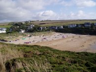
(5) Mawgan Porth |
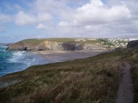
(6) Trenance Point |
The first main beach that is reached is Mawgan Porth which is about 2.5 miles from Watergate Bay. Photo 4 was taken as I approached the beach. The path leaves the cliffs and joins the road for a short distance to cross over the River MMenalhyl before headig across the sand at the top of the beach to re-join the path as it ascends once again to the top of the cliffs on the way to Porthcothan, some 4.5 miles distant. Photo 5 was taken looking back to the beach. Leaving Mawgan Porth the path passes through some very attractive scenery near Trenance Point, photo 6, with views opening up towards Trevose Head in the distance.
 |
 |
 |
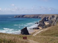
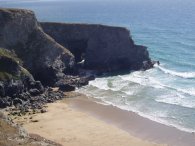
(7) Bedruthan Steps |
(8) Diggory's Island |
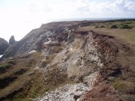
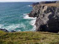
(9) Coastal Erosion |
Photo 7 was taken from Carnewas Point looking across the beach at Bedruthan steps and photo 8 looking back to Diggory's Island. The coast in this area is continually suffering from erosion, photo 9, and in several places the route of the coast path has had to be moved inland as the old route of the path has dropped into the sea.
 |
 |
 |
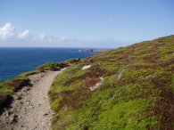
(10) SWCP nr Park Head |
(11) Porth Mear |
(12) Trescore Islands |
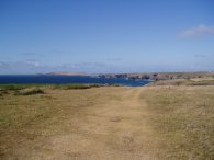
After the long drive down from London it was really enjoyable to have the opportunity to stretch my legs in such pleasant countryside as the path headed over the cliff tops, photo 10, towards Porthcothan. In the distance the lighthouse of Trevose Head could be seen illuminate by the sunlight. Not far from Porthcothan the path descend down to pass the small beach at Porth Mear, photo 11, before climbing back up over the headland opposite the Trescore Islands, photo 12.
 |
 |
 |
(13) Porthcothan Bay |
(14)Porthcothan Beach |
(15) Warren Cove |
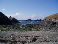
The path then heads towards Porthcothan Bay, photo 13, heading down to the sand dunes at the end of the beach. The path passes a small shop before turning left onto the road for a short distance to the far side of the beach where another left turn leads up along a path the climbs steadily up the cliffs at the side of the beach. When I was a child we used to visit Porthcothan quite regularly. In those days the two rocks in the centre of photo 13 used to form an arch which has now been completly eroded away to leave current stacks. Photo 14 was taken looking back over the beach from the cliffs on the far side. From Porthcothan it is another two mile walk to the next main beach, Treyarnon. The path is fairly level as it makes its way past Fox Cove, Warren Cove, photo 15, and Pepper Cove before descending down to Treyarnon Bay.
 |
 |
 |
(16) Treyarnon Bay |
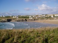
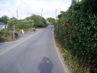
(17) Constantine Bay |
(18) Constantine |
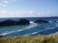
The path crosses over the beach at the top end of Treyarnon Bay, photo 16, and takes a path that runs alongside the Youth Hostel round the short distance to Constantine Bay, photo 17. From Treyarnon Bay it was signposted as another 4.5 miles to Harlyn, around Trevose Head. This was a little to far as it was getting late and thus I ended my walk at Constantine. My phone was not receving a signal on the coast so I headed up the road from the beach, photo 18, towards the village of Constantine where a pay phone was marked on the map. Typically, just as I reached the payphone I also got a signal on my mobile and thus could arrange to be collected for the short trip back to my parents.
The GPS made this walk 9.82 miles long.
![]() Back to:Walking index page
Back to:Walking index page
| ©2008 Bertuchi.co.uk. Please contact me if you have any questions or comments regarding the site. Additional information about places of interest on the walks is always welcomed. All rights reserved. Please contact me if you want to use any of the images or information from the site. Thank you. |
|