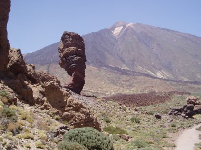
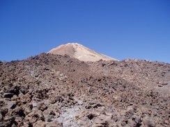
(1) Pico del Teide
PICO DEL TEIDE - TENERIFE
Spains highest Mountain
|
|
(1) Pico del Teide |
I climbed the Pico del Teide on 30th July 2006 although my preparations had begun a few days earlier. To reach the very top of the mountain you need to obtain a permit from the National Park Offices in Santa Cruz de Tenerife. The number of permits issued each day are limited to 150 and these are allocated into four two hour time slots, 9am - 11am, 11am - 1pm, 1pm - 3pm and 3pm - 5pm.
 |
 |
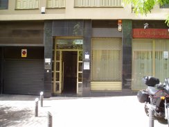
(2) Entrance to the National Park Offices in Santa Cruz |
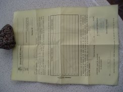
(3) The Permit |
The National Park Offices, photo 2, are located on the 4th Floor of number 5, Calle Emilio Calzadilla which is close to the Plaza España in Santa Cruz. There was no obvious sign in the entrance doorway for the office however a quick ride up in the lift to the fourth floor led to their small offices. I visited the offices on Tuesday the 25th and the next available permits were for Friday the 28th, there was availability for all times on the 30th and I chose between 1pm and 3pm. To get the permit you need to give them a photocopy of your passport, a small stationery shop directly opposite the park offices has a photocopier which I used to copy my passport for 20 cents. After completing a short form I was then handed my permit, photo 3. This then needs to be shown, along with your passport, to the park ranger who guards the final section of path up the mountain.
 |
 |
(5) Start of the Montaña Blanca Trail |
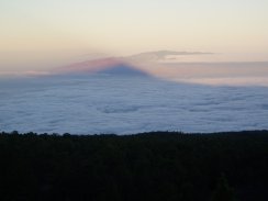
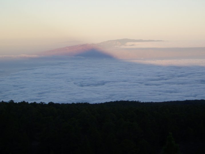
I set off from Callao Salvaje at 7:00am and reached the start of the trail at 8:15. As I was driving up the mountain from the coast the sun was rising and I was able to stop and get a photograph of the shadow of Mount Teide being cast across the cloud covered sea and on to the Island of Gomera, photo 4. (Click the green text below the photo to see a larger version). The start of the trail is marked by a sign, photo 5, showing the route up to Montaña Blanca. The path up to Teide leaves this route just before summit of Montaña Blanca is reached.
 |
 |
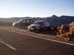
(6) Parking at the start of the trail |
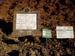
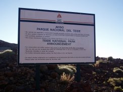
(7) National Park Information Board |
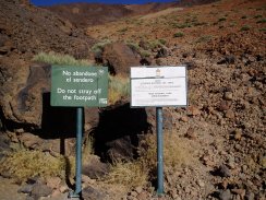
My two main concerns about this walk were the effects of the high altitude and the temperature. When I had been walking on Mount Guajara a few days earlier my walking pace was noticeably slower than normal as I found myself getting out of breathe even easier than usual and it had been baking hot, around 30c. Mid summer is probably not the best time to attempt this walk and I carried four litres of water and isotonic drinks with me. I also drank as much as I possibly could before setting off from the car which I had been able to park at the side of the road opposite the start of the walk, photo 6. There are a few more parking places on the other side of the road too. A sign near the start of the walk, photo 7, reminds visitors that "For conservation and safety reasons free access to the Teide Peak (3717 mts) is not allowed" and that "One can only use the footpath that leads up to the Teide Peak as far as La Rambleta (3550 mts)" - unless of course you have your permit and passport with you!
 |
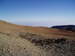 |
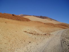
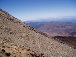
(8) Slopes of Montaña Blanca |
(9) Slopes of Montaña Blanca |
The first couple of miles of the walk is a fairly easy and gentle climb up towards Montaña Blanca following a jeep track used by the park rangers, photo 8. As the track winds its way up the side of Montaña Blanca the views gradually increase, photo 9. Despite my worries about the heat the early morning started quite cool in the mountains, the display in the car showing only 9c when I set off which along with the good track led to a very pleasant start to the walk. I was wearing a long sleeved T shirt and also long trousers, primarily to protect me from the sun along with a new wide brimmed sun hat to keep the sun off my neck but at this stage they also helped me keep a bit warmer.
 |
 |
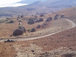
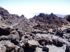
(10) Los Huevos del Teide |
(11) A old lava flow down the mountain |
In photo 10 the track can be seen curving round the Huevos del Teide, or "Eggs of Teide". These are giant boulders of basalt that have rolled down the mountain during an eruption having broken away from the main lava flow, rather like giant snowballs. Photo 11 shows the course of a lava flow down the side of the mountain.
 |
 |
(12) The start of the trail to Teide |
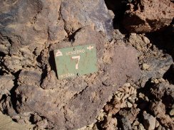
(13) A Sendero 7 way marker |
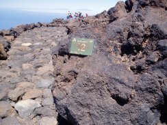
After about 80 minutes walking the route up Teide leaves the Montaña Blanca track and heads off to the right along a steep path up the mountain. The start of the path is marked by a couple of signs, photo 12, which once again remind visitors of the park requirements. The National Park Office has a map listing 21 walks within the park and the walk up to La Rambleta is their walk number 7. Occasionally small green plaques, photo 13, have been placed along the course of the route.
 |
 |
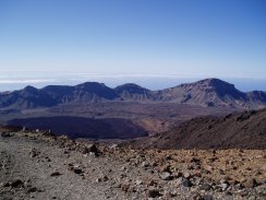
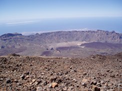
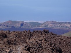
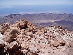
(14) View over Las Cañadas crater |
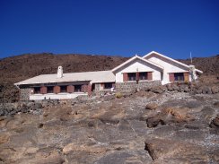
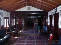
(15) The Refugio de Altavista |
The path up the mountain is well defined although often quite steep and rocky with almost no level sections. It was a case of just walking along steadily uphill. The rough nzture of the path gave my boots quite a battering. While there were ever increasing views back across the crater of Las Cañadas, photo 14, there was not much of a view up the mountain, the horizon always seeming quite near by. Eventually a metal pole is spotted on the horizon which marks the location of the Refugio de Altavistsa although it is sometime before the Refugio itself actually appears, photo 15.
 |
 |
(16) Inside the Refugio de Altavista |
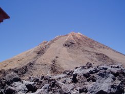
(17) View towards the summit of Teide |
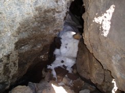
The Refugio de Altavista is at an altitude of 3260 mts and looks very like an old fashioned English Youth Hostel, photo 16, with several domitories leading off from the main room and a small self catering kitchen. It had taken me 2hrs 40 minutes to reach the refugio and I stopped for a 15 minute break on a bench outside. Details of how to stay at the refuge can be found in English at the following website Refugio de Altavista. Leaving the refugio the path continues to head steeply uphill across lava towards the Mirador Forteleza. Progressing upwards, the summit of Teide finally appears over the horizon, photo 17. On the way the path passes the Cueva del Hielo, or ice cave, which is just a short detour off the main path although somehow I managed to miss the side path to the cave although I did not realise this till I reached the Mirador. At one point I had strayed slightly off the main path on a sub track and I can only assume it was while I was on this bit of path that I missed the turn off to the cave.
 |
 |
(18) The path close the Mirador Forteleza |
(19) Snow in Tenerife |
Photo 18 shows the path just before the Mirador Forteleza is reached. Arriving at the Mirador was a bit of a shock as you are suddenly amongst all the tourists who have ascended Teide by the cable car wandering around in their flip flops and sandals. After a quick stop to admire the view I then continued on to the cable car station at La Rambleta which I reached just after 12:10pm, or 3hrs 55 minutes after I had left the car. On path between the Mirador Forteleza and the cable car station, which is the National Park route 11, I passed a spot where some snow could be seen packed deep down between the rocks, photo 19.
 |
 |
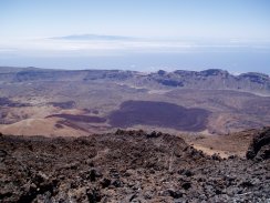
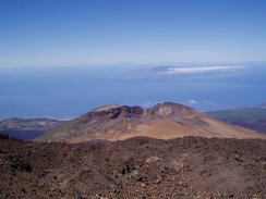
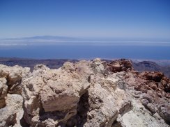
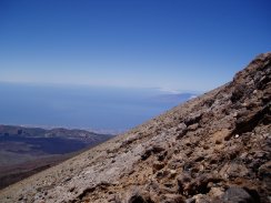
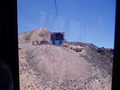
(20) View to Gran Canaria |
(21) View over Las Cañadas crater |
Photos 20 and 21 were taken overlooking the Las Cañadas crater from near to the cable car station. The island of Gran Canaria can be seen in the distance in photo 20.
 |
 |
(22) A Sendero 12 way marker |
As I still had 50 minutes before my time slot to visit the summit I headed along path 12, photo 22, which leads from the cable car station to the Mirador de Pico Viejo which as the name suggests looks out over the crater of Pico Viejo, photo 23. The islands of Gomera and Hierro can be seen in the background.
 |
 |
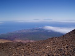
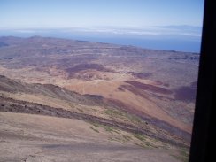
(24) View towards La Palma |
(25) View from the Mirador de Pico Viejo |
Photo 24 was taken just to the right of photo 23 and shows the island of La Palma in the background. Photo 25 was taken just to the left of photo 23 looking down towards the coast near where I was staying. The Mirador was a very peaceful spot, despite the altitude there was hardly any wind blowing and the place was completely silent as I sat and had my lunch.
 |
 |
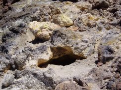
(26) A Steam Vent |
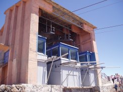
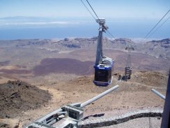
(27) The Cable Car Station |
From the Mirador I made my way back up path 12 again, passing a small steam vent, photo 26, on the way to the cable car station, photo 27, ready for the climb up the final 168 mts to the summit of Teide. It was 1:15pm when I presented my permit and passport to the park ranger at the base of the path and was allowed to pass the chain across the path. The ranger said that I had to be back in an hour.
 |
 |
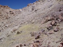
(28) Steam Vent and Sulphur Deposits |
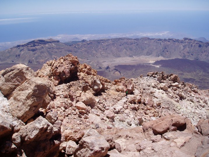
(29) View from the summit of the Pico Del Teide |
The final climb up to the summit is quite steep and it was here for the first time that I started to feel quite tired and short of breathe and I needed a couple of short rest stops, although even at my slow walking pace I managed to pass a number of people on the way up which probably took me about 20 minutes.
Photo 28 shows an area of sulphur vents just below the summit which were giving off there distinctive odour of rotten eggs. Photo 29 is of the summit of the Pico del Teide at a height of 3717 mts or 12178 feet.
 |
 |
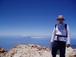
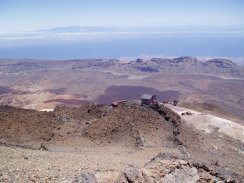
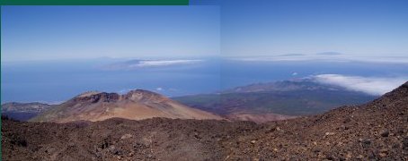
There was very little cloud cover and there were good views in all directions across Tenerife as I sat down on the summit and waited for six for seven minutes for someone to join me so I could get my photo taken, photo 30, standing at the top of the peak. Photo 31 shows the final section of path up to the summit along with the Las Cañadas crater in the background from which I had climbed up from, some 1400 mts below. In total I had walked 6.42 miles to get to the summit which includes my diversion to the Mirador de Pico Viejo.
 |
 |
(32) View back to the Cable Car |
(33) View along the Cumbre Dorsal |
Photo 32 was taken as I decended from the summit, looking over the cable car station. As I descended I debated wether to walk down the mountain or take the cable car back. I was still feeling quite fit but in the end I decided to take the cable car, it would have been quite late by the time I would have got back to the car and I was worried about slipping on the rough surfaces as I did not have my walking pole with me which is always a great help on steep descents. It was also quite fun to have a ride on the cable car, it having been many, many years since I had last been on one. Photo 33 was taken looking over the side of the mountain along the Cumbre Dorsal, the mountainous spine that runs along to the North East of the island from Teide.
 |
 |
(34) Pico del Teide |
(35) Pico del Teide |
Photo 34 was taken looking in the other direction over the side of the summit cone. Photo 35 was taken from besides the cable car station looking back up towards the summit. It took me just over an hour to make the round trip up to the summit, admire the views and come back down again. On the way down I passed one of the couples I had gone by on the way up still slowly ascending! Upon returning to the La Rambleta your permit is returned to you by the park ranger and can be kept as a souvenir.
 |
 |
(36) The Cable Car |
(37) View from the Cable Car |
It was then on to the cable car to get a ticket for the descent back down the mountain, feeling slightly out of place with my rucksack and big boots amongst those who were making the return trip. The cable car runs a very frequent service and I did not have to wait long before a cable car, photo 36, arrived at the station. A few minutes later I was on the cable car and looking back up towards the station, photo 37.
 |
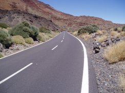 |
(39) The TF-21 road |
There were great views over the mountain as the cable car descended, although a bit small to make out in photo 38, the road where I had parked the car and the first part of the walk over the side of Montaña Blance were clearly visible. All too soon though the cable car was back at the base station and it was time for the 1.75 mile walk back along the TF-21 road, photo 39, to the car. This was a straight forward bit of walking along the edge of the road although at some points there was not much of a verge to walk along and visibilty round some bends was a bit poor so I had to pay careful attention to the traffic, fortunately the road was not too busy and I made good time back to the car. At the bottom of the crater the temperature was much warmer than earlier, the car display said 27c when I got back and I had drunk 3 of the four litres of drink I had carried with me.
 |
(40) View over Pico Viejo |
The GPS made this walk 8.61 miles long and was without doubt this was one of the best walks I had ever done. The walk up the side of the mountain through the volcanic scenery, with the views opening up over the Cañadas Crater and gradually the whole of the island, was truly superb. There are many places I'd like to go back to, this is one place I'm definitley coming back to.
The walk does not require a map, the trail is perfectly easy to follow however I found the 1:50,000 scale AA Island Map of Tenerife quite useful while on the island. It has the main walking paths marked on it and although not marked across the main map it has the local Pico de las Nieves grid (or "Pico De Las" as shown on my GPS) shown on the sides of the map. The grid reference I recorded on the summit was N 28.16.278 WO 16.38.433.
![]() Back to:Walking index page
Back to:Walking index page
| ©2008 Bertuchi.co.uk. Please contact me if you have any questions or comments regarding the site. Additional information about places of interest on the walks is always welcomed. All rights reserved. Please contact me if you want to use any of the images or information from the site. Thank you. |
|