Rochester Centenary Walk
Other Links >>> |
|
A CIRCULAR WALK FROM ROCHESTER
Incorporating the Rochester Centenary Walk
|
|
Rochester Centenary Walk |
I did this walk on Sunday 16th September 2012. On older versions of the Ordnance Survey Maps for the area (163 and 148) there is a recreational trail marked called "Centenary Walk Rochester". There were also similar Centenary walks devised in Canterbury and Maidstone to celebrate the centenary of the Kent County Council which took place in 1989. These walks appear to have not been promoted for some time and I have been unable to find any real information about them on the internet. On the ground the routes had once been way marked although now almost none of this way marking remains. However while the routes remained marked on the OS maps both the Canterbury and Maidstone centenary walks, which were both circular walks, were relatively easy to follow. The Rochester walk however has always appeared more confusing. From the map the route appears to be a linear walk rather than a circular one. In addition the Saxon Shore Way, Medway Valley Walk and North Downs Way all pass in or around Rochester which led to the walk having no unique route of its own apart from a very short stretch along Rochester High Street. The words "Centenary Walk Rochester also only appear once on the map, running alongside the river Medway close to the town centre. With no additional information available this meant it was unclear where the start and finish points of the walk had actually been. A few weeks earlier I had walked the Medway Valley Walk and whilst doing this walk had spotted four way marks, all very close together near Borstal, relating to the Centenary Walk and decided to set out to see if I could find any more.
 |
 |
 |
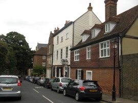
(1) Rochester High Street |
(2) Crow Lane |
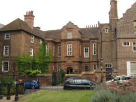
(3) Restoration House, Rochester |
From my parking spot in Canal Road I headed over the Medway Bridge and up Corporation Street before heading up Blue Boar Lane to the High Street, photo 1. Here I headed to the left up to Star Hill. I then turned right soon bearing to the right along Delce Street and then turning right along King Street where I linked up with the route of the Saxon Shore Way. These are not the most attractive streets in the area however the end of the High Street would have been a logical place for the Centenary Walk to start. Leaving King Street I then headed to the right down Union Street before heading left along East Row. This soon leads to a road junction where I headed right down to the top of Crow Lane, photo 2, opposite the Vines, which is the site of a medieval vineyard where monks from the nearby St. Andrew's Priory, at Rochester Cathedral, once grew grapes for their wine. On the maps there is, or was, a green diamond marking a recreational trail on the map on Crow Lane and this did not coincide with the routes of any of the paths mentioned earlier so I think I was fairly safe in assuming I was now on the route of the Centenary Walk. I headed down the lane, passing the Restoration House, photo 3, which is a fine example of an Elizabethan mansion. It is so named after the visit of King Charles II on the eve of his restoration.
 |
 |
 |
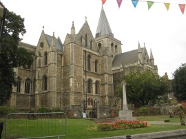
(4) Rochester Cathedral |
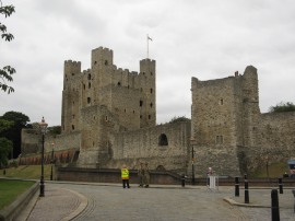
(5) Rochester Castle |
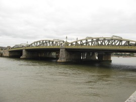
(6) Rochester Bridge |
At the end of Crow Lane I headed to the left along the High Street, passing by Rochester Cathedral, photo 4, and the Rochester Castle, photo 5. Reaching the end of the High Street then I headed over to the Esplanade by the Rochester Bridge, photo 6 where I linked up with the route of the Medway Valley Path. From this point onwards there were no parts unique to the route of the Centenary Walk as marked on the map and I was once again left to guess where it went.
 |
 |
 |
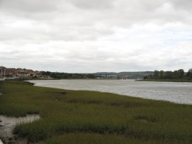
(7) River Medway, Rochester |
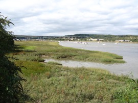
(8) Salt Marsh besides the river |
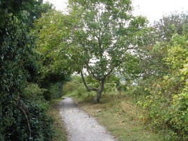
(9) Footpath by Baty's Marsh |
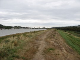
Joining the Esplanade I first headed through the riverside gardens and then alongside the road as the route makes its way upstream alongside the river Medway. It is roughly at the point where photo 7 was taken that "Centenary Walk Rochester" is marked on the Ordnance Survey maps. It was a grey day although then sun did briefly come out as I was heading along the Esplanade lighting up the salt marsh that lines this stretch of the river. Reaching the end of the Esplanade the route joins a footpath, photo 9, which runs in-between Borstal Recreation Ground and Baty's Marsh.
 |
 |
 |
(10) Walk Way Marker 1 |
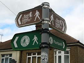
(11) Walk Way Marker 3 |
(12) Walk Way Marker 4 |
This stretch of path is followed up to Manor Lane where I passed the first of the way marks for the walk, photo 10. Continuing along Manor Lane to the entrance into Medway Bridge Marina the path joins a footpath on the left where there was the second of the remaining way markers for this walk. A short distance down this path the route joins a footpath on the left where there was the third of the way markers for the walk, this time a white round disc, photo 11. This footpath is followed uphill to run behind houses up to the Wouldham Road. When I had walked this stretch of path a few weeks earlier it had been very overgrown with rampant nettles but these had now all been cut back, completely changing the nature of the path. Reaching the Wouldham Road there was the fourth and final way marker that I spotted, photo 12, pointing off to the right down the road. These way marks are the same that were used for the Canterbury and Maidstone walks although on this walk I saw no more asides from these four which were encountered in quick succession.
 |
 |
 |
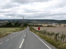
(13) Wouldham Road |
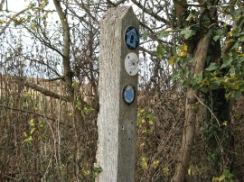
(14) Way marking post |
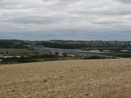
(15) View back to the Medway Bridge |
I then headed down the Wouldham Road, photo 13, passing under the M2 before heading to the right along Nashden Farm Lane. This followed down to the buildings by Nashden Farm were I headed off to the right along a footpath that starts heading uphill to the North Downs. This path crosses a bridge over the Channel Rail Link and shortly after crossing over the railway lines the footpath heads briefly to the right before continuing ahead along a field edge path running alongside the Shoulder of Mutton Wood. Where the path heads right there was a wooden pole, photo 14, with way makers for both the North Downs Way, Medway Valley Walk and also a bridle path and then just three nails which had obviously once held another way marker disc in place and I wondered whether this had been for the Centenary Walk. As the path ascended there were good views back down to the Medway Valley and road and rail bridges crossing the river, photo 15.
 |
 |
 |
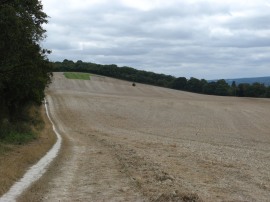
(16) Path by Shoulder of Mutton Wood |
(17) School Lane, Wouldham |
(18) View over to Halling |
Continuing on I followed the path along the edge of the field from where there were more good views up the Medway Valley and out over Woudlham. I had a short snack stop on a wooden bench before continuing on to the end of the field. Reaching the trees that can be seen at the end of the field in photo 16 I followed the route of the Medway Valley path which starts heading downhill along a broad stony track to reach the Pilgrims Way. Crossing the road, the path passes a very isolated post box and heads down School Lane, photo 17, into the village of Wouldham. As mentioned before I had no idea where the Centenary Walk ended but decided to walk no further than Wouldham which did seem it could be a logical place for the walk to end. First I headed to the left through the village along the High Street before joining a footpath on the right that heads down Ferry Road. This heads past a terrace of houses and joins a track which runs down to reach the river Medway at the site of the old Halling to Wouldham Ferry, photo 18. A ferry ran here for about 600 years before closing in 1964 following the opening of the new Medway Bridge carrying the M2. Now all that remains is a set of concrete steps heading down into the water on either side of the river. I stopped here and had my lunch looking across the river before retracing my steps back into Wouldham, the footpath leading to the former ferry site being a dead end.
 |
 |
 |
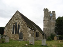
(19) All Saints Church, Wouldham |
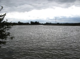
(20) River Medway at Wouldham |
(21) Debris floating on the river |
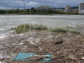
Back in the village I headed along the High Street, passing All Saints Church, photo 19, before joining a footpath on the left that headed the short distance down to the river. It was pretty much high tide, photo 20 and the river appeared very full and there were a number of water skiers taking advantage of the conditions. For a while the footpath moves away from the river, skirting around the edge of an area of marsh before once again heading back to the flood wall besides the river. A little further on down the river, opposite the old Halling Cement Works there was a door was floating around in the debris by the riverbank, photo 21.
 |
 |
 |
(22) Housing on Big Wood Road |
(23) Approaching the Medway Bridges |
(24) Under the Medway Bridges |
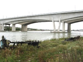
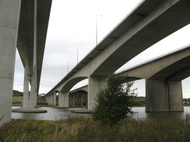
I then continued on along the riverside path all the way back to Rochester. On my map the footpath is shown as leaving the riverside and heading inland to the Rochester Road however a new right of way has recently been opened alongside the river and looking at the wear and tear of the path along the top of the flood bank I believe this has been used as a footpath for quite some time anyway, photo 22. This path carried me past the Wouldham Marshes and down towards the three bridges that carry the Channel Tunnel Rail Link and M2 motorway across the river Medway, photo 23. This was the first time I had ever walked under the bridges and it was interesting to note the different styles of their construction. Once under the bridges the footpath skirts round the edge of some residential moorings before joining an enclosed stretch of footpath that leads back to the Medway Bridge Marina where I linked up with my outward bound route as I made my way back through Baty's Marsh and along the Esplanade back to my parking spot. On the final stretch up to Rochester bridge I noticed that quite a few jellyfish had been washed up along the waters edge by the high tide, something I wasn't expecting to see at all.
Back at the car I had walked 12.3 miles. In the end I am not sure how accurately I had followed the route of the old Centenary Walk - Rochester, however this had been a good circular walk with the outward stretch heading past the historic buildings of Rochester and then up along the North Downs and with a good riverside walk for the return leg. If anyone reading this does have any recollections about the Centenary Walk please do drop me a line.
As usual I have uploaded the route of the walk which can be accessed here: route.
![]() Back to:Walk index page
Back to:Walk index page
| ©2012 Bertuchi.co.uk. Please contact me using the email button on the right if you have any questions or comments regarding the site. Any feedback and additional information about places of interest on the walks is always welcomed. All rights reserved. Please contact me if you want to use any of the images or information from the site. ENJOY YOUR WALKING |
|