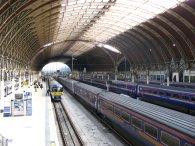
(1) Paddington Station
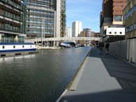
(2) Paddington Basin
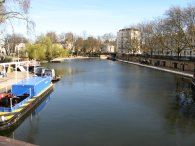
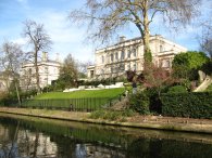
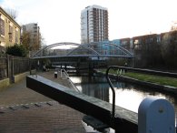
(3) Little Venice
REGENTS CANAL PATH
|
|
|
|
(1) Paddington Station |
(2) Paddington Basin |
(3) Little Venice |
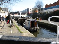
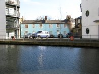
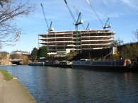
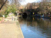
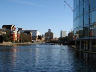
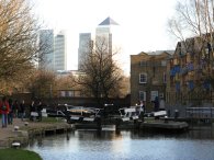
I did this walk on the 11 March 2007. After finishing the last five or so miles of the New River Path I took the tube over from Angel to Paddington Station, photo 1, from where it was just a short walk along London Street to join the Regents Canal at the Paddington Basin. This is an area where there has been a massive amount of regeneration in recent years and the whole area is now lined with offices, homes, shops and leisure facilities, photo 2. From here it was another short walk along the canal side to reach Little Venice, formed where the western end of the Regent's Canal and the Paddington arm of the Grand Union Canal meet up, photo 3.
 |
 |
 |
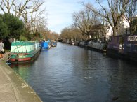
(4) Regents Canal, Little Venice |
(5) Houses, Regents Park |
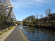
(6) Passing London Zoo |
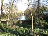
Crossing over the canal I then started heading down the Regent Canal towards the Maida Hill tunnel, photo 4. The path passes a number of boat moorings where the path runs along the road for a short distance before reaching the tunnel. At the entrance to the tunnel the route crosses the Edgware Road and heads along Aberdeen Place as it passes over the Maida Hill Tunnel, taking a footpath straight ahead when the road turns to the left. From here the path soon descends a flight of metal stairs to rejoin the canal bank. The path passes through another basin at Lisson Grove with quite a large number of moored houseboats and continues on under some tube lines and the A41 before running opposite some of the very grand houses that line the outer circle in Regents Park, photo 5. A little further along the canal passes through the grounds of London Zoo which lines the canal bank on either side for a short distance, photo 6.
 |
 |
 |
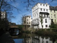
(7) Canalside House, nr Primrose Hill |
(8) Camden Lock |
(9) Kentish Town Lock |
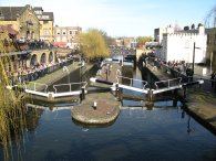
There was lots of interesting buildings to see besides the canal and when I got home I found I had taken over 80 photographs which was probably why the walk seemed to take so long to do, I was stopping every few feet to get the camera out! Photo 7 is of one of a number of fine houses that line the canal side. As usual the full size version of the photo looks far more impressive than the reduced version on the website. Leaving the edge of Regents Park the canal turns to the left and makes its way down towards Camden Lock, photo 8. It was a pleasant spring day and the whole length of the Regents Canal towpath was being well used by people however the area around Camden Lock was completely packed by young people enjoying the amenities in the area. A little further on the canal passes through Hawley Lock and Kentish Town Lock, photo 9, and continues to makes its way through Camden and on down towards Kings Cross.
 |
 |
 |
(10) Cottages, Kings Cross |
(11) Kings Cross Basin |
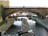
(12) St Pancras Lock |
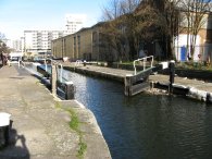
There is a lot of new development taken place along the side of the Regents Canal, as it happening with many of the other waterways that run through London like the River Lea. Near to Kings Cross I spotted a couple of brightly painted old cottages flanked on either side by large modern developments, photo 10. Soon the path passes Kings Cross basin, photo 11, (where my neighbour has his houseboat moored) and reaches St Pancras Lock. Ahead the gothic spires of St Pancras station could be seen along with a lot building work associated with the channel tunnel rail link. Most of the Regents Canal was built with double lock gates although for almost all of the locks only one is now in use. At St Pancras lock the second lock acts as a weir with the water flowing over the sides of the old lock, photo 12.
 |
 |
 |
(13) New buildings, York Way |
(14) Islington Tunnel |
(15) Islington Tunnel, Colebrooke Row |
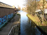
Close to York Way another large development is being built besides the canal, photo 13. The path then passes Battlebridge Basin and heads under the Caledonian Road towards the Islington Tunnel, photo 14. The Islington Tunnel is 996 yards long and was opened along with the canal in 1820. It is just possible to see light shining through from the other end of the tunnel in the photo. For the length of the tunnel the route is forced to leave the canal side and head through the streets of Islington. The path climbs uphill along a footpath that runs through a housing estate before heading past a small play area and down Tolpuddle Street. Crossing Liverpool Road I headed round the N1 shopping centre and briefly along Upper Street before turning down Duncan Street to reach Colebrooke Row, high above the Eastern End of the tunnel, photo 15.
 |
 |
 |
(16) Canal Tunnel waymarker |
(17) City Road Basin |
(18) Sturt's Lock |
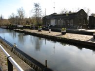
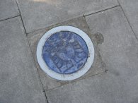
At several locations colourful blue disks, photo 16, had been set in the path indicating the Islington canal tunnel link route although not in sufficient numbers to make the route easy to follow without having some sense of where you were heading. I had passed along Colebrooke Row earlier in the day when walking along the New River Path however on this occasion I headed down to rejoin the canal path. I headed past the City Road Basin, photo 17, from where the Nat West Tower could be seen away in the distance and on past Sturt's Lock, photo 18.
 |
 |
 |
(19) Gasholders, Bethnal Green |
(20) Victoria Park |
(21) Old Ford Lock |
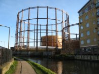
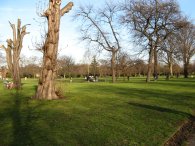
A little further down the path the towpath was closed for renovation work and I had to divert along Barings Road for a short distance. A long fairly straight stretch of canal then heads along, running past De Beauvoir Town to the left and Hoxton to the right before passing under the A10 and entering the lower reaches of Dalston. The path passes another basin near Shoreditch and continues on past the Haggerston Estate. For a while on this section there where little signs besides the path giving the time needed to walk between the various bridges the cross the canal which seems quite a good idea. At a bend in the canal the path passes the gasholders at Bethnal Green, photo 19 and heads under Mare Street to reach the edge of Victoria Park, photo 20. Here the canal towpath was also closed so I had to walk through the park, parallel with the canal until I was able to rejoin the towpath just above Old Ford Lock, photo 21.
 |
 |
 |
(22) Hertford Union Canal |
(23) Mile End Lock |
(24) View towards Canary Wharf |
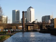
From Victoria Park the route crosses over the start of the Hertfordshire Union Canal, photo 22, and runs down towards Limehouse Basin besides the Mile End Ecology Park to the left and the buildings of Queen Mary University to the right. As the towpath heads past Mile End Lock, photo 23, one of twelve locks on the canal, the buildings of Canary Wharf start looming ever larger on the horizon. Just past the Mile End Stadium a lone brick built chimney stands isolated besides the canal bank in stark contrast to the modern buildings behind it. It had been a lovely bright sunny Spring day but the sun was now starting to get low on the horizon and I needed to stop and put on a warmer fleece as the air started to cool down.
 |
 |
 |
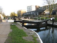
(25) Salmon's Lane Lock |
(26) Commercial Road Lock |
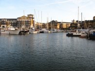
(27) Limehouse Basin |
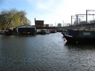
The next lock passed is Johnson's Lock and then Salmon's Lane Lock, photo 25. From there it is not much further until the towpath meets the Commercial Road Lock, photo 26. Through the lock the Regents Canal enters the Limehouse Basin, photo 27, at the other end of which is the River Thames. The GPS made it a distance of 8.6 miles to the basin from Paddington Station.
Leaving Limehouse Basin I retraced my steps briefly to take the Docklands Light Railway from Limehouse station to start my journey home. The total mileage I had walked for the day was 15.3 miles. This had been another enjoyable walk with plenty to see and one I would definitely recommend it to anyone who has a few hours to spare in London.
![]() Back to:Walking index page
Back to:Walking index page
| ©2008 Bertuchi.co.uk. Please contact me if you have any questions or comments regarding the site. Additional information about places of interest on the walks is always welcomed. All rights reserved. Please contact me if you want to use any of the images or information from the site. Thank you. |
|