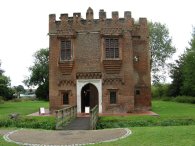
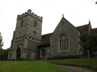
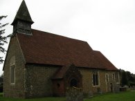
(1) Rye House Gatehouse
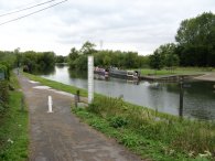
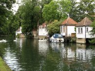
(2) River Lea, nr Rye House
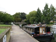
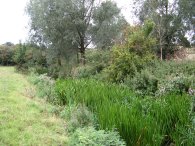
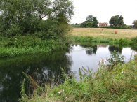
(3) River Lea, nr Stanstead Abbots
Other Links >>> |
|
THE HERTFORDSHIRE WAY - DAY 20
Rye House to Hertford
I did this walk on Sunday 19th August.
|
|
|
|
(1) Rye House Gatehouse |
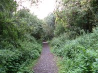
(2) River Lea, nr Rye House |
(3) River Lea, nr Stanstead Abbots |
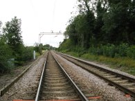
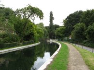
I drove up from Walthamstow and parked in the small car park by the Rye House Gatehouse, photo 1, from where it was only a very short walk up to Rye House Station to rejoin the route of the Hertfordshire Way. From the station the route continues along the road for a few yards to join the Lea Valley Path, photo 2. At this point the Lea Valley path being separated from the New River by barely more width of the railway lines. The route then continues along the tow path of the River Lea Navigation for one and a quarter miles up to Stanstead Abbots, photo 3, where, just after passing the Lea Valley Marina, the route leaves the River Lea and turns right along the B181 to pass along Stanstead Abbots High Street.
 |
 |
 |
(4) Stanstead Abbots |
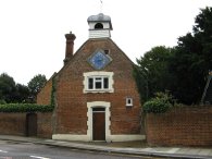
(5) St Andrew's Church, Stanstead Abbots |
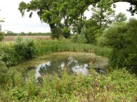
(6) Fish pond |
At the end of the High Street the route turns left along Cappell Lane, photo 4, continuing past the church of St Andrew, photo 5, before taking a footpath off to the right. The footpath heads gently uphill and is signposted Wareside two and three quarter miles. The route heads steadily uphill, the footpath joining a farm track as it approaches the top of the hill. At the top of the hill the route passes a pond in a field in which there were a large number of gold fish swimming, photo 6, which is not something one often sees in a field side pond.
 |
 |
 |
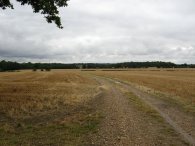
(7) Heading towards Wareside |
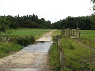
(8) River Ash |
(9) River Ash |
The wheat in the fields besides the footpath had been harvested and the straw gathered in, photo 7. A clear sign of the seasons progressing which got me thinking back to the ploughed muddy fields when I started my walk around the Hertfordshire Way back in January. The route follows the farm track for about a mile and a half until, just past a red bricked farm house, it curves round to reach the route of the old railway that ran between St Margarets and Buntingford. The line was opened in 1863 and closed just over 100 years later in 1964. Here the route turns left and then soon turns left again to cross a wooden footbridge beside a ford over the River Ash, photo 8. About 75 yards further along the route turns to the right and heads along a track that runs past a timber fronted house. At a bend in the track the path continues ahead over a stile into a field. After a while the path runs along side the river Ash, although this was quite overgrown, photo 9. At a corner of the field the footpath turns left to continue along the field edge before exiting over a broken down stile in the corner of a field in a patch of dense scrubby woodland.
 |
 |
 |
(10) Heading towards the River Lea |
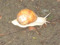
(11) Roman Snail |
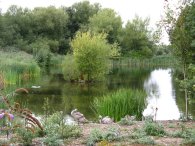
(12) Amwell Nature reserve |
The route then heads over another wooden bridge over the River Ash. to rejoin the track bed of the old railway, photo 10, as the Hertfordshire Way makes it way steadily back down to the Lea Valley not far away from where the route had left the river earlier. Walking along the path I spotted a Roman Snail, photo 11, the first one I had seen in this area. The route was initially quite overgrown but after having passed under a road bridge the track became clearer as it headed down towards the ponds of the Amwell Nature reserve, photo 12, and another wooden bridge over the river Ash. The route crosses a bridge over the River Lea and continues along the track bed of the old railway line to where it had originally branched off from the main line to Hertford East.
 |
 |
 |
(13) Railway Crossing, nr St Margarets |
(14) Amwell Island |
(15) Hardmead Lock |
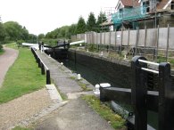
Here the route turns to the left and then right along a concrete track that leads to a gravel track where the route crosses over the railway lines, photo 13. Once over the railway line the route continues ahead along the gravel track which leads back up to the New River path at Great Amwell where the Hertfordshire Way turns right along the river bank. Reaching Amwell Island, photo 14, the route turns left over a wooden bridge and heads up a flight of steps to the road by St John the Baptist Church where the route turns right for a very short distance before taking a footpath off to the right again to head down to the New River. The route does not go down Lower Road (as I initially did) but continues once again along the New River path. Reaching a road the route turns right down a gravel track along footpath number 9 that leads to the Lea Valley, crossing back over the railway lines and joining the River Lea by the Hardmead Lock, photo 15.
 |
 |
 |
(16) Canal boats at Ware |
(17) Summerhouses, River Lea at Ware |
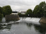
(18) Weirs, Ware Lock |
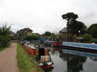
The route then heads up beside the River Lea Navigation towards Ware. Just outside the town there were a number of canal boats moored, photo 16. Passing through the centre of Ware the towpath also passes a number of summerhouses built out over the canal, photo 17, and continues up the towpath to pass the weirs besides Ware Lock, photo 18.
 |
 |
 |
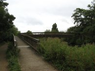
(19) Bridge over the River Lea |
(20) River Rib |
(21) St Leonards Church, Bengeo |
The route crosses over the River Lea at the next bridge, photo 19, and then turns left to head along the other bank of the river, initially passing through the edge of a sports ground, and then under the A10 flyover. The route then follows a hedge and tree lined path that takes a fairly straight course, a few yards distance above the River Lea Navigation. Reaching some buildings the route continues ahead along a roughly tarmac surfaced track to reach a road. At the road the route then turns sharp left to a wooden bridge over the River Rib, photo 20, before heading over a patch of scrubby ground. The Hertfordshire Way then crosses over another smaller bridge and heads down towards a much larger concrete bridge over the River Beane. Just before this bridge is reached the route turns right along a grassy track that heads uphill towards a church, where the route heads through the churchyard of St Leonards Church at Bengeo, photo 21.
 |
 |
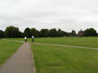
(22) Broxbourne Pumping Station |
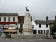
(23) Hertfordshire War Memorial |
Leaving the churchyard the route heads downhill through the trees along a broad tarmac track before forking left to take a bridge over the River Beane and enter the playing fields by the Hertford Leisure Centre, this recreation area is also known as Hartham Common. Crossing the common I made my way up Hartham Lane, past the McMullen Brewery. I then turned left to make my way into the town centre of Hertford where I finished both this stage of the Hertfordshire Way by the Hertfordshire War Memorial, photo 23. The total distance I had walked from Rye House Gatehouse was 10.3 miles so that made 10.2 along the Hertfordshire Way for the day.
From Hertford I walked back down the River Lea to Rye House which gave a total distance walked of 16.4 miles. It was my first day back from holiday in Spain and it was nice to stretch my legs after the plane journey. The weather was grey and gloomy and I got caught in one shower as I was walking back to the car although this did not last too long. Reaching Hertford for the second time also means I have now completed the Hertfordshire Way path in its entirety. The total length of the path as recorded by my GPS was 184.6 miles.
![]() Back to:Walk index page
Back to:Walk index page
| ©2012 Bertuchi.co.uk. Please contact me using the email button on the right if you have any questions or comments regarding the site. Any feedback and additional information about places of interest on the walks is always welcomed. All rights reserved. Please contact me if you want to use any of the images or information from the site. ENJOY YOUR WALKING |
|