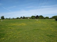
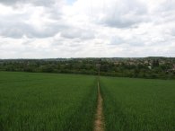
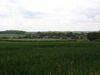
(1) Fields nr Sandridge
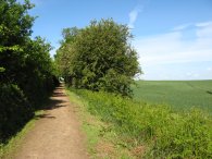
(2) Heading towards the A1081
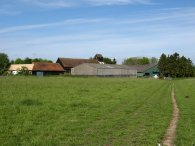
(3) Cheapside Farm
Other Links >>> |
|
THE HERTFORDSHIRE WAY - DAY 12
Sandridge to Redbourn
I did this walk on Sunday 20th May. I was able to park by the church in the village of Sandridge almost exactly where I had finished my last walk along the Hertfordshire way. In complete contrast to last weeks rain soaked walk the day started dry and still with only a few small clouds visible on the far horizon.
|
|
|
|
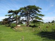
(1) Fields nr Sandridge |
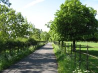
(2) Heading towards the A1081 |
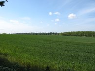
(3) Cheapside Farm |
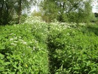
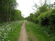
From the church the route leads through the village, turning right besides the village hall to pass through a playing field. Leaving the playing field, the route then heads over two fields, photo 1, before crossing over a minor road to take a hedge lined lane, photo 2. This is then followed for some distance as the route crosses over Cheapside Rail bridge, passes through the building of Cheapside Farm, photo 3, and then turns right along the farm track that runs over very pleasant farming countryside as the Hertfordshire Way makes its way to the A1081 Harpenden Road.
 |
 |
 |
(4) Path to Childwick Green |
(5) The Childwick Estate |
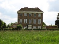
(6) Path past Childwick Bury |
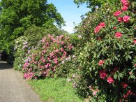
Reaching the A1081 the route heads to the right, following the road round a bend before turning left through a gated driveway along a road signposted St Marys Church and Childwick Green. The route makes its way along a rhododendron lined road, photo 4, to the church and the hamlet of Child wick Green where the route turns left and continues along a driveway that runs through the middle of the estate, photo 5, passing the very large Childwick Bury house on the way which is where the film maker Stanley Kubrick lived until he died in 1999. The route eventually leaves the estate road, photo 6 taking a bridleway that bears off to the left. This is followed through trees by Ladies Grove wood for some distance before heading out into open fields, soon to run down the side of a golf course on the left.
 |
 |
 |
(7) Views over the Ver valley |
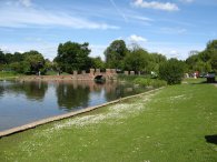
(8) Lake, Verulamium Park |
(9) Roman Wall, St Albans |
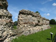
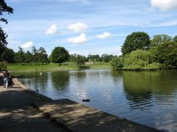
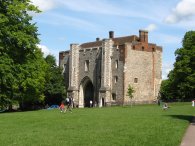
This path curves round the edge of the golf course with fine views over the Ver valley on the right, photo 7, to reach a small road where the Hertfordshire Way turns right. Heading along the track St Albans Abbey comes into view for the first time. At the end of the track the route turns right onto a larger road. The Hertfordshire Way then continues ahead to cross over a roundabout into the A 4147 Bluehouse Hill. Here the route heads down the road, over the river Ver, then turns left down Saint Michaels Street before turning right in front of the Verulamium museum where the Hertfordshire Way commence a short loop round St Albans. The route heads through the car park and into Verulamium park before turning left to head down to some ornamental lakes. The first lake was being used model boat enthusiasts with some quite impressive boats, including remote controlled sail boats. The route heads along the right hand bank besides the lake, photo 8, before heading diagonally uphill to run past a stretch of the old Roman Walls of the city of Verulamium (St Albans), photo 9. This stretch of wall formed part of the Eastern defences of the city and was built between AD 256 and 270.
 |
 |
 |
(10) Lake, Verulamium Park |
(11) St Albans Abbey |
(12) St Albans Abbey |
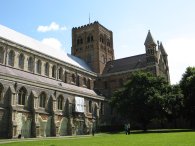
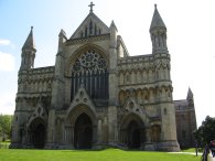
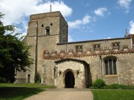
Reaching a footpath at the end of the wall the route turns right to head briefly uphill to reach the site of an old roman gatehouse before turning round and heading back down hill past the head of the lakes, photo 10. Crossing over the River Ver, the route turns right past the Fighting Cock pub and then left to head uphill towards the Abbey, photos 11 and 12.
 |
 |
 |
(13) Abbey Gateway |
(14) Fishpool Street |
(15) Path towards Maynes Farm |
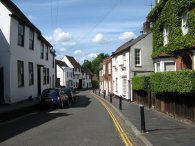
Reaching the Abbey the route turns left, the right to head through an imposing gatehouse, photo 13, before following the road round to the left along Fishpool Street, photo 14. This road eventually makes it way back to St Michaels Road to pass the side of the museum at the start of the St Albans loop of the Hertfordshire Way. Continuing back uphill the route crosses over the A4147 and then heads down through a gated path that leads past an old Roman Theatre just off to the left for which there is an admission charge. The Hertfordshire Way itself runs along a tarmac track lined in part by horse Chestnut Trees, photo, 15. This is a permissive path that leads to Maynes farm and may not always be open.
 |
 |
 |
(16) Ver Valley |
(17) River Ver |
(18) Path besides the River Ver |
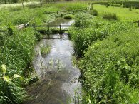
From St Albans the route of the Hertfordshire Way had also been following the route of the way marked Ver Valley walk and after about half a mile the route takes another track that runs downhill over the valley floor, photo 16, to the right to cross over the River Ver once again, photo 17. Once over the river the route takes a narrow, and when I walked it, rather overgrown section of path, photo 18, that runs alongside the river bank to eventually reach the Redbourn Road.
 |
 |
 |
(20) Ford by Redbournbury Farm |
(21) Redbournbury Mill |
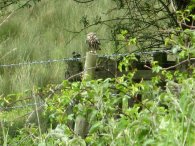
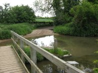
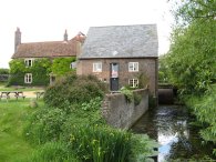
Crossing the road the route heads down another estate track which is followed round to the left, past an old mill building and alongside the river Ver over open fields. The path leaves the farm track and takes a tree lined footpath that continues to run alongside the river which is very overgrown with reeds with little open water to be seen. On the opposite bank I spotted a Little Owl, photo 19, perching on a fencepost. Reaching a ford by Redbournbury Farm, Photo 20, the route turns left over a little bridge before making its way up past Redbournbury Mill< photo 21, where the route turns right along a track that leads down the side of the mill house.
 |
 |
 |
(22) Nicky Line, Redbourn |
(23) St Mary at Redbourn Church |
(24) West Common, Redbourn |
This track runs over fields to cross back over the A5183 and continues up a footpath on the other side of the road. Reaching the main road on the outskirts of Redbourn the Hertfordshire Way heads across the road and up Chequers Lane and takes a footpath up to the left that leads onto the Nicky Line, photo 22, the old railway that used to run between Harpenden and Hemel Hempstead. A lot of works were going on besides the path associated the widening of the nearby M1 motorway. Leave the Nicky Line the route takes a footpath down to the parish church of St Mary at Redbourn, photo 23, where I ended this stage of my walk. At this point I had done 10.1 Hertfordshire Way miles for the day.
From the churchyard I headed down Church End, and along up West Common past the Redbourn cricket club, photo 24, as I started to make my way back to the car at Sandridge.
 |
 |
 |
(25) Field nr Redbourn |
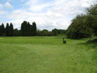
(26) Harpenden golf course |
(27) House by Harpenden golf course |
I had a little explore along Redbourn High Street before heading down Waterend and making my way back down to cross the Nicky Line and the A5183 again. Once over the road I headed up into a field, photo 25. Here the path runs uphill through a field of wheat and through a hedge into a grassy field before turning right to take a path that ran through a patch of scrubby woodland. From here the path comes out by Harpenden golf course where it skirts the 8th tee, named rather aptly as "Ramblers Risk" and heads down the golf course, photo 26. Just past the ninth tee the footpath turns right, once again into a patch of scrubby woodland before heading out beside the golf course past an impressive house, photo 27, to join a minor road where I turned left.
 |
 |
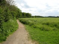
(28) Footpath to Codicote Bottom |
(29) Approaching Sandridge |
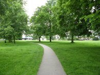
At the end of the road I turned right onto the main road I then right down Oakfield Avenue into a very palatial estate of large houses. At the end I turned left into Oakfield Road then right into Dellcroft Way. Making my way through the estate I then turned left into West Common Road and right into West Common Grove. This becomes a footpath that on leaving the estate leads to another road where I turned left to headed down a short distance to cross the St Albans Road. Once across the road I turned left up Cross lane from where I took a grassy track that crossed over Harpenden Common up to East Common Road. At the end of the road I then turned left along Ayres End Lane. Crossing over the railway lines I took a bridleway that runs off to the right, photo 28. This initially runs downhill besides fields before rising gently from the bottom of a small dry valley. Passing Langley Wood the path starts heading downhill again along a broad gravel surfaced track that leads down into Sandridge, photo 29.
Back at the car the total distance I walked for the day was 15.7 miles.
This had been an enjoyable walk with plenty of variety. I was able to make a decent circular walk which allowed me to make some good progress around the Hertfordshire Way and there was plenty too see from the buildings of St Albans and the Abbey, the Childwick Estate and River Ver. The highlight of the walk though had to be spotting the Little Owl. It was also dry!
![]() Back to:Walk index page
Back to:Walk index page
| ©2012 Bertuchi.co.uk. Please contact me using the email button on the right if you have any questions or comments regarding the site. Any feedback and additional information about places of interest on the walks is always welcomed. All rights reserved. Please contact me if you want to use any of the images or information from the site. ENJOY YOUR WALKING |
|