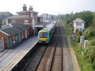
(1) Rye Station
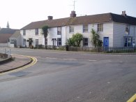
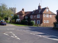
(2) Houses, Hamstreet
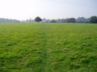
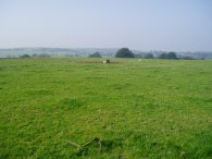
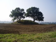
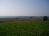
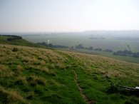
(3) Fields Nr Warehorne
SAXON SHORE WAY
Hamstreet to Rye
|
|
|
|
(1) Rye Station |
(2) Houses, Hamstreet |
(3) Fields Nr Warehorne |
Arriving at Ham Street station I crossed over the tracks and headed down the footpath on the other side to rejoin the Saxon Shore way at the end of the Hamstreet National Nature reserve. The path goes down Bourne Lane and turns right onto the B2067, at this point called the Ruckinge Road. The path continues ahead at a crossroads, past the houses in photo 2, into Warehorne Road. Just after passing under the A2070 the Saxon Shore Way takes a footpath off the left, parallel to the road for a short distance before heading over a stile and across the fields in photo 3. It was at this point I realised I had forgotten to start my GPS at Ham Street station, however I soon got a satellite lock and continued on my way.
 |
 |
 |
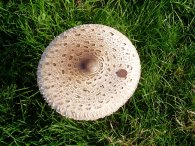
(4) Giant Mushroom |
(5) Fields nr Warehorne |
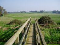
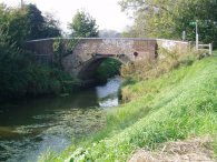
(6) Bridge over the Horsemarsh Sewer |
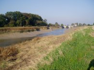
The path heads through Warehorne along a minor road passing the church and Woolpack pub before turning left down the driveway of Tinton Manor Farm. After a very short distance the path then heads right over a gate and across the middle of a field. In this field there were some of the largest mushrooms I had ever come across, photo 4. The brown circle on the right of the mushroom cap is a 1p coin which I put there to give some indication of scale. The path continues across another larger field, photo 5, before turning left and heading downhill to cross a wooden bridge over the Horsemarsh Sewer. Photo 6 was taken from the bridge looking back over the fields I had just walked. The bright sky, green fields and trees making it seem much more like an early summer day than the middle of October.
 |
 |
 |
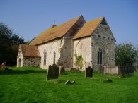
(7) St Mary's Church, Kenardington |
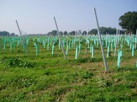
(8) New vines |
(9) Field nr Appledore |
From the Horsemarsh Sewer, the path heads gently uphill towards the isolated St Mary's Church, Kenardington, photo 7. Leaving the church the path heads up and crosses a minor road and continues over fields towards Appledore. Just past Smiths Farm, as the path heads gently down to a road with the trees of Rushfield Wood away to the right I passed a newly planted vineyard, photo 8. The path heads straight across the road and across another set of fields. On the way I met an elderly gentleman out walking and we both agreed it was a glorious day to be out enjoying the countryside. The first field was growing some kind of leafy crop, unfortunately I had no idea what it was, but the route of the path was fairly clear and it was quite easy to walk through. After about half a mile the path reaches the top of a small hill where photo 9 was taken. The route was a bit unclear at this point but goes over the middle of the small hill in photo 9 and then heads diagonally downhill under the power lines towards Appledore. This field had all been newly ploughed however the dry soil meant that it was quite easy to walk over and I presume as a few more people cross it the route will become a bit more defined once a gain. I would not have liked to have crossed it after heavy rain though.
 |
 |
 |
(10) Appledore |
(11) View over Romney Marsh |
(12) Stone Ferry Bridge |
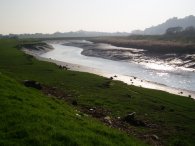
Reaching Appledore the Saxon Shore Way is signposted over a playing field but when I was there a football match was in progress so I went down a side road instead to reach the B2080 which is then followed through the village. At the end of the village, just before the road starts heading downhill the Saxon Shore Way turns right down Court Lode Road, opposite the church, photo 10. A short distance further on the path leaves the road on a footpath that runs off to the left just past Court Lodge. This path runs over a small hill as the land drops away on all sides, photo 11. The path leaves the hill and goes over a stile and onto a path that runs round the side of a field to jion the drainage ditch known as the Reading Sewer. This is then followed until the Appledore Road is reached, photo 12. Having crossed the "sewer" by the bridge the route passes through the car park of the Stone Ferry Pub and continues along the other bank. The field to the left of the path was being ploughed and a large number of seagulls were eagerly following the line of the plough.
 |
 |
 |
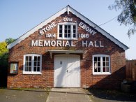
(13) Stone-cum-Ebony Memorial Hall |
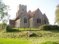
(14) St Mary's Church, Stone in Oxney |
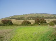
(15) The 'cliff' top path |
Just past a small pumping station the Saxon Shore Way leaves the Reading Sewer and follows a smaller drainage ditch off to the left until a farm track with a bridge over the drainage ditch is reached. The path turns left over the bridge and follows a concrete farm track, past a very smelly pile of manure, up towards a road. As the farm buildings are reached the path leaves the track and runs just inside a field on up to the road. The path crosses this road and takes a driveway beside a house and gardens before turning left into a set of fields which are crossed, going gently uphill towards Stone in Oxney. The Saxon Shore Way crosses the main road and heads along Church Hill, passing the Stone-cum-Ebony Memorial Hall in photo 13. The path continues climbing uphill along the road, passing the St Mary's Church, photo 14, to a T junction with Knock Hill. Here the path crosses the road and heads over a field to once again reach the edge of the old cliff line, some 50 metres above the surrounding countryside, photo 15, looking down over Romney Marsh and the valley of the River Rother.
 |
 |
 |
(16) Stone Cliff |
(17) Iden Lock |
(18) River Rother |
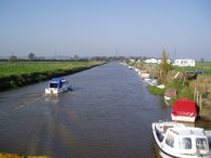
From this point the only way is down and the path heads down Stone Cliff to cross over a few fields on its way to rejoin the Royal Military Canal. Photo 16 was taken looking back towards the Stone Cliff to where photo 15 had been taken from. Once again the path alongside the Royal Military Canal, although grassy, was quite uneven to walk along and the actual canal was often obscured by trees. At Iden Lock the Saxon Shore Way rejoins the road for a short distance before crossing over to the other bank of the canal. Iden Lock which was built in 1808 marks the junction of the Royal Military Canal and the River Rother however although the lock itself has now been turned into a sluice one of the old lock gates can just be made out in the foreground of photo 17. Below the lock the nature of the path changes with path running besides open fields next to the river. Immediately below the lock the river bank was lined for several hundred yards by a number of caravans some of which can be seen to the right in photo 18. As well as following the Royal Military Canal Path at this point the Saxon Shore Way has also linked up with the Sussex Border Path for the way to Rye.
 |
 |
 |
(19) River Rother |
(21) Ypres Tower, Rye |
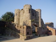
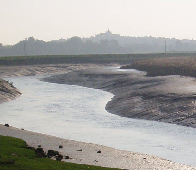
The Saxon Shore Way continues alongside the river for about a mile to Scotts Float Sluice which can just be seen in the background on photo 19. Below this point the River Rother is tidal and it must have been quite near low tide as I made my way towards Rye as there were large mudbanks exposed alongside each bank of the river. As I made my way down river the town of Rye gradually came into view on the horizon. In the larger version of photo 20, (click on the green text above), the Church of St Mary the Virgin in Rye can be seen silhouetted on top of the hill. Although the weather was still very warm and summer like one indication that it is approaching the winter months is that by mid afternoon the sun was already quite low on the horizon and as I while walking directly into it with an ever increasing shadow trailing behind me it made getting a decent photo of the view ahead impossible. The path follows the flood embankment round under the railway bridge which I had passed over earlier in the day on my way to Hamstreet and continues on to join the A259, using the road bridge to cross back over the River Rother. Once over the river the path runs alongside some playing fields before crossing the main road again and taking a flight of steps up into the centre of Rye towards the Ypres Tower, photo 21.
 |
 |
 |
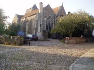
(22) Church of St Mary the Virgin, Rye |
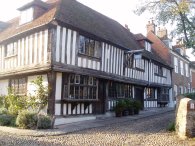
(23) Old building, Rye |
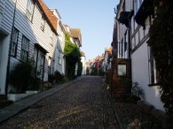
(24) Mermaid Street, Rye |
From the Ypres Tower with its views over Romney marsh and the River Rother the Saxon Shore Way heads along a path to Church Square and the Church of St Mary the Virgin, photo 22. Turning right past the church the route heads into Watchbell Street, passing the building in photo 23 which is on the corner of West Street. At the end of Watchbell Street the path turns right down Traders Passage which runs down to the Mermaid Street, photo 24. Rye is a very attractive old town with a large number of historic old buildings and it is well worth spending some time looking around. From Mermaid Street the route heads along the Deals, back down to the main road and River Tilingham.The Saxon Shore Way takes the road bridge to the left over the river, however I headed off to the right along Wish Street and back to the station.
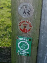 |
(25) Way Markers |
The GPS made this walk 13.6 miles. I had fitted new insoles to my walking boots since my last walk in an attempt to help my feet feel less tired at the end of the day however by the end of the day my feet were still feeling quite tired and sore, however this may be because the new insoles need a certain amount of wearing in. Only time will tell.
![]() Back to:Walk index page
Back to:Walk index page
If you would like to comment on this walk you can do so here:
| ©2008 Bertuchi.co.uk. Please contact me if you have any questions or comments regarding the site. Additional information about places of interest on the walks is always welcomed. All rights reserved. Please contact me if you want to use any of the images or information from the site. Thank you. |
|