(1) Faversham
(2) Faversham Guildhall
(3) Oyster Bay House
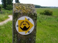
SAXON SHORE WAY
Faversham to Herne Bay
|
|
|
|
(1) Faversham |
(2) Faversham Guildhall |
(3) Oyster Bay House |
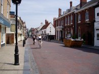
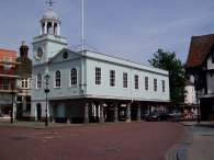
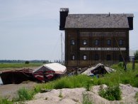
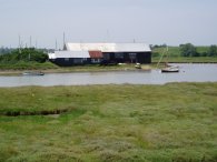
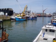
Photo 1 was taken in Preston Street and photo 2 is of the Faversham Guildhall. Faversham is a nice place to visit with lots of interesting an old buildings and the Shepherd Neame Brewery to visit and in the warm weather seemed almost continental. I passed the brewery and in Abbey Street I joined up with the route of the Saxon Shore Way as it made its way along the road and down through a boatyard to join the Faversham Creek. Just past the boatyard the path passes by The Oyster Bay House, photo 3, which originally started life as a store for hops which were being taken by barge to London.
 |
 |
 |
(4) Faversham Creek |
(5) Saxon Shore Way Marker |
(6) Junction with Oare Creek |
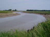
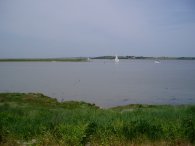
The Saxon Shore Way then runs alongside Faversham Creek, photo 4, which forms a big dog leg as it makes its way round to the junction with Oare Creek, photo 6, and for some distance I was heading back in a westerly direction rather than east down the coast.
 |
 |
 |
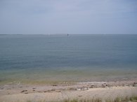
(7) Swale Estuary by Faversham Creek |
(8) View towards Shellness |
(9) View towards Whitstable |
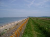
Just past the junction of the two creeks the path enters the Swale Estuary nature reserve as it follows the creek back to the Swale Estuary, photo 7. The path on the other side of the creek being only a few yards across the water but at least four miles away by foot. This is the end of the last big diverson the path takes and the Saxon Shore Way now follows the coast in a relativley straight line all the way to Whitstable. Whilst in the Swale Nature Reserve besides Nagden Marshes I was fortunate enough to spot a Marsh Harrier. There were numerous signs saying that one was breeding and asking people not to linger so that the bird would not be scared to visit its nest but to be honest I was not expecting to see one. The path runs along the top of the sea wall and I first spotted it from the embankment at not much more than head height. Initially too me looking quite similar to a buzzard, although less chunky. It circled up on the thermals rising higher and higher until it eventually dissapeared from sight somewhere overhead. A really great sight.
The day was starting to get very warm and once I had left the nature reserve I needed to stop and get my sun screen out which doesn't happen that often. As the path progresses down the coast the Isle of Sheppy gradually become more distant, photo 8, and the Swale is eventually left behind. Photo 9 was taken looking East along the sea wall towards Whitstable.
 |
 |
 |
(10) Saxon Shore Way, Nr Chitty |
(11) Whitstable |
(12) The Royal Native Oyster Stores |
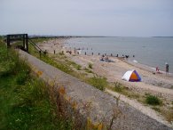
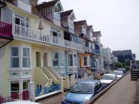
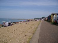
The path continues on past the Sportsman pub and on towards Seasalter. As the route progresses towards Whitstable the amount of shingle besides the sea wall gradually increases till there is sufficient to form small beaches, photo 10, and with it being such a warm day these were quite busy. The path joins the Faversham Road just before Seasalter and after passing through a private estate along Preston Parade climbs slightly uphill and heads inland for a short distance. The path then runs along besides Joy Lane before a footpath to the left heads back downhill, over the railway lines, and back to the sea front where it runs past rows of beach huts and into the centre of Whitstable. Photo 11 shows some sea front houses and photo 12 is of the Royal Native Oyster Stores.
 |
 |
 |
(13) Whitstable Harbour |
(14) Tankerton Promenade |
(15) View towards Herne Bay |
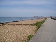
Passing through Whitstable I had a quick look round the harbour, photo 13, before continuing along the road to Beach Walk. There were a number of seafood stalls in the harbour and Ihad been going to buy some prawns but the woman in the queue in front of me started giving such a long and complicated order that in the end I gave up waiting and continued on. From Beach Walk the Saxon Shore way turns right and joins the Tankerton Promenade, photo 14, which is followed for some distance. Not that I have any memory of it, Tankerton was where I was born and spent the first few weeks of my life. The promenade was lined for much of its length with beach huts and once again the beach was quite busy. Eventually the promenade ends and the path heads slighty inland across an area of rough ground before rejoining the seafront and another promenade, photo 15, that leads all the way to Hampton on the outskirts of Herne Bay.
 |
 |
 |
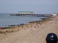
(16) Herne Bay Pier |
(17) Herne Bay Pier |
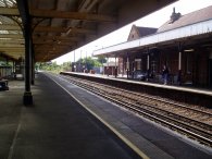
(18) Herne Bay Station |
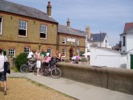
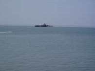
By the time I reached Hampton I was starting to feel quite tired and also thirsty due to the the hot weather so I stopped of in a pub for a pint of orange and lemonade before continuing past Hampton Pier and along the seafront at Herne Bay. Out at sea I could see the remains of the end of Herne Bay Pier, photo 16. At 1147mts this was once the second longest pier in the country. The end of the pier was closed in 1968 and the head has been isolated out at sea since a storm destroyed the majority of the pier in 1978. Photo 17 shows the surviving landward side of the pier. Reaching the pier I left the seafront, and the Saxon Shore Way, and headed up the aptly named Station Road to Herne Bay Station, photo 18, to catch the train back to Faversham. This was packed with day trippers to the coast and it was standing room only.
The GPS made this walk 14.5 miles long. It had been nice to be back on the Saxon Shore Way and the weather had been perfect for spending a day walking along the coast.
![]() Back to:Walk index page
Back to:Walk index page
If you would like to comment on this walk you can do so here:
| ©2008 Bertuchi.co.uk. Please contact me if you have any questions or comments regarding the site. Additional information about places of interest on the walks is always welcomed. All rights reserved. Please contact me if you want to use any of the images or information from the site. Thank you. |
|