(1) Gravesend Town Pier
(2) Gravesend Town Pier
(3) Path by Gravesend Marina
Other Links >>> |
|
THE SAXON SHORE WAY - PART 1
Gravesend to Cooling
I did this walk on Sunday 13th July 2008, starting immediately after completing the Wealdway Walk which conveniently finishes besides the start point of the Saxon Shore Way. The Saxon Shore Way is the next walk for the walking group and although I have already walked all of the Saxon Shore Way at various times between 2004 and 2007 I have only written web pages for the stages from Faversham onwards and thus am definitely going to join them as far as Faversham to enable me to complete the missing sections of the walk. It's great company and I'd love to do all the walk with them however it is along way down to the depths of Kent from Walthamstow to walk paths that I have comparatively recently walked, particularly as I will be heading down that way a fair bit in the near future on the North Downs Way.
|
|
|
|
(1) Gravesend Town Pier |
(2) Gravesend Town Pier |
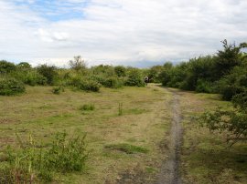
(3) Path by Gravesend Marina |
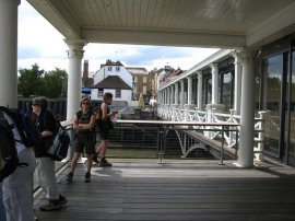
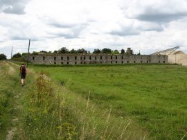
The walk started on Gravesend Town Pier which is the oldest remaining cast iron pier in the world and was designed by William Tiernwey Clark in 1834. The pier had recently been modernised and now has a very swanky restaurant at the pier head. From the pier the group walked the short distance to the gardens besides the Three Daws Pub where we stopped for lunch. Four of the group that had completed the Wealdway then left and the remaining five of us set off down the Thames. Opposite the pub was where I saw the first waymarker for the Saxon Shore Way on a lampost on West Street. The route, which is well signposted in Gravesend, follows Royal Pier Road round to the right, away from the riverfront before turning to the left and heading back down besides the river Thames along Gordon Promenade. Leaving the promenade the path heads over the entrance to the Gravesend Embankment Marina, photo 3. Below the lock gates a boat was waiting in the narrow entrance creek although the tide was quite low and it was clearly going to be a number of hours before it could enter the marina.
 |
 |
 |
(4) Thameside Industrial Estate, Gravesend |
(5) Thames and Medway Canal |
(6) Gravesend Tugboats |
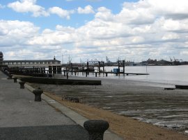
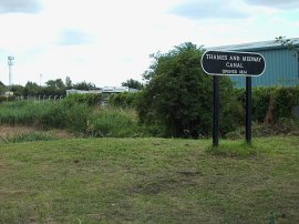
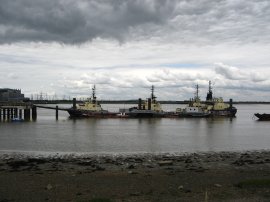
From the marina the path then heads through a very run down and forbidding industrial estate photo 4, before reaching Wharf Road. While we were walking along a narrow stretch of footpath through the estate we had to stop as a group of probably at least fifty Sikh walkers passed by us in the opposite direction. The route heads along Wharf Road and then turns down Mark Lane to rejoin a path along the Thames Embankment, passing the Fish and Lobster pub. At the junction of Wharf Road and Mark Lane it is possible to see the remains of the Thames and Medway Canal, photo 5, which had opened in 1824. It was originally some 11 km (7 miles) long and cut across the neck of the Hoo peninsula, linking the River Thames at Gravesend with the River Medway at Strood. The Higham and Strood tunnel on the canal is 3.5 km (2.25 miles) long, and was the second longest canal tunnel built in the UK. In 1846 the canal company sold the tunnel to the South Eastern Railway company, which filled the canal and laid a double railway track over it which is still in use today. Later on the Saxon Shore Way passes the remains of the old lock gates where the canal used to join the River Medway. On the river a number of tugs from the Svitzer fleet were moored at a jetty, photo 6.
 |
 |
 |
(7) Path along the flood bank |
(8) Cobelfret Ferries MS Yasmin |
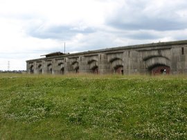
(9) Shornmead Fort |
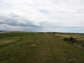
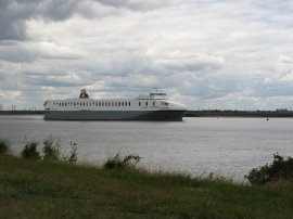
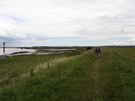
Leaving the industrial area's behind the Saxon Shore Way then heads off down river, running besides the River Thames on the top of the flood bank, photo 7. This was a rather long straight and rather dull section of path, although it was nice to be walking alongside the Thames again. As we made our way down the river we were passed by the Cobelfret Ferries MS Yasmin, a 200mtr ship launched in 2007, photo 8. About three miles from Gravesend the path passes in front of the Shornmead Fort. In 1796 a battery was built at Shornmead to strengthen the Thames defences and Shornmead was developed into one of the first polygonal forts between 1847 - 53. This was in turn replaced by the present fort in the 1860s which consisted of an arc of granite-faced casemates with iron shields, photo 9, and an open battery at the up-river end. After 1945 it fell into decay and in the 1960's much of the fort was demolished. For much of this section of walk we were accompanied by the rather noisy sound of numerous off road bikes which always seem to be using this area.
 |
 |
 |
(10) Path along the flood bank |
(11) Cliffe Pools |
(12) Old Wooden Boat |
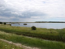
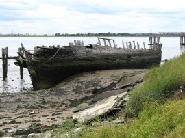
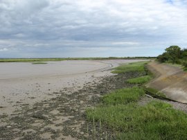
From the fort the route continues on down besides the Thames, photo 10, passing a red painted light, to reach the Cliffe pools, photo 11, a series of old flooded gravel pits. Nearing the first pool the Saxon Shore Way turns to the left to take a path along a narrower and more overgrown stretch of floodbank that runs down to Cliffe Fort with the pool on the right and the Thames on the left. Despite the path being generally well waymarked there was no obvious sign that the route turns to the left at this point. As the path heads towards Cliffe Fort it passes an old, and very rotten wooden boat on the mudflats, photo 12, as well as what also looked like the remains of some concrete barges.
 |
 |
 |
(13) Cliffe Fort |
(14) Saxon Shore Way Marker |
(15) Gravel Conveyor, Cliffe Fort |
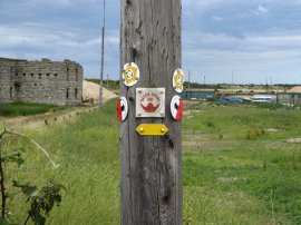
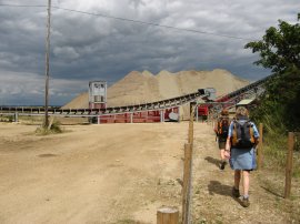
The site of Cliffe Fort, photo 13, is now owned by a gravel company and the fort itself has long been abandoned and is now very overgrown. Just before reaching the fort the path passes an old Saxon Shore Way marker attached to a telephone pole, photo 14, confirming we were on the right route. Cliffe Fort was built in the 1860's as part of the Thames defences and is more or less opposite Coalhouse Fort on the other side of the Thames. In 1890 a Brennan land based torpedo was added and the launching rails can still be seen leading down to the river, photo below. These were a land based installation armed with wire -guided and powered torpedoes which were in operation between 1890 and 1906. The route heads along a narrow path between the river and the fort, passing the torpedo rails and then passes across a more open patch of ground where the way marked route has been moved slightly to the right to pass under a gravel conveyor, photo 15. The conveyor seemed very shiny and new and had not been in place the last time I had walked this stretch of path.
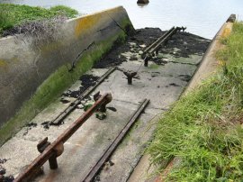 |
Brennan Torpedo Launch Rails |
 |
 |
 |
(16) Path nr Cliffe Creek |
(17) Cliffe Creek |
(18) View over Cliffe Marshes |
Having passed under the conveyor the route follows the edge of the river for a short distance before turning to the right across a stretch of scrubby ground, photo 16, and heading up besides Cliffe Creek, photo 17. The route turns to the left to cross the top of the creek before continuing up over a low concrete wall to turn left along a broad cinder track. A short while further on the route of the Saxon Shore Way turns sharp right to head almost back on itself along a path that runs between two of the Cliffe Pools, although the pool on the right hand side of the path is generally obscured from view. Last time I had been here this had been a very overgrown section of path with the remains of numerous burned out cars. However since the area has been acquired by the RSPB the path has been widened, a new (rather noisy) surface laid, and the old cars removed which made it much more pleasant to walk through. Reaching the end of the pools the route turns to the left along a broad track along the top of the pool. Passing through a big black vehicle barrier the route turns briefly left, then right, to continue along another unsurfaced track with the fields of Cliffe Marshes on the left, photo 18, into the village of Cliffe. On the other side of the river the towers of the Coryton Oil refinery and oil storage tanks on Canvey Island could clearly be seen. Just before Cliffe is reached there is a Saxon Shore Way sign on a telephone pole, the first that we had seen since the gravel conveyor belt which would have made navigation through the Cliffe Pools very difficult without a map or previous knowledge of the correct route .
 |
 |
 |
(19) Fields nr Cliffe |
(20) Rhubarb |
(21) Field nr Cooling |
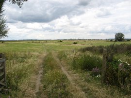
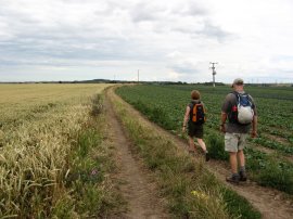
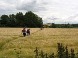
Entering Cliffe the route heads gently uphill past St Helen's church and along Church Street before continuing ahead where the road bends to the right past, a small shop into Swinegate Avenue. Here the route of turns to the left, passing between houses, over a road and out into open fields, photo 19. Reaching Common Lane the route turns to the right along the road for a short distance before joining a footpath on the left where the road bends to the right. This runs over a number of small fields, including one that was planted with a crop of Rhubarb, photo 20 and another with Barley, photo 21 as the path makes its way to the Cooling Road.
 |
 |
 |
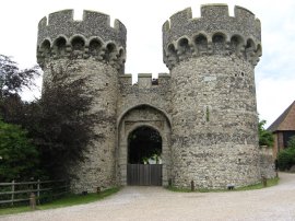
(22) Cooling Castle Gatehouse |
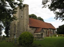
(23) St James's Church, Cooling |
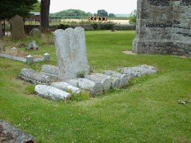
(24) Graves, St James's Church, Cooling |
Reaching Cooling Road it was just a short distance along the road to St James's Church in Cooling where we had parked the cars at the start of the day. Before we reached the church we passed the gatehouse of Cooling Castle, photo 22. The rest of the castle is much more incomplete although it is possible to spot the remains of the walls and moat in a number of places. In the churchyard of St James's Church, photo 23, are the group of children's gravestones, photo 24, which prompted Charles Dickens to write the opening of the novel Great Expectations where Pip meets Magwitch and which was where we ended our walk for the day.
Reaching the car we had, according to my GPS walked 8.8 miles from Gravesend although I think the actual distance was probably nearer 9.5 miles. This, along with the stretch of the Wealdway we had walked earlier gave a total distance of 15.6 miles for the day. I felt unusually tired at the end of this walk and was glad to have reached the car when we did. Later on in the week I came down with quite a heavy cold and I wonder whether I already had the virus in my system at this time. It had been almost four years since I had last walked this part of the Saxon Shore Way and in a number of places the quality of the path had been improved from then although it really does need signposting properly around the Cliffe Pools.
If you would like to comment on this walk you can do so here:
![]() Back to:Walk index page
Back to:Walk index page
| ©2012 Bertuchi.co.uk. Please contact me using the email button on the right if you have any questions or comments regarding the site. Any feedback and additional information about places of interest on the walks is always welcomed. All rights reserved. Please contact me if you want to use any of the images or information from the site. ENJOY YOUR WALKING |
|