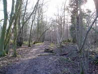
(1) Hertfordshire Way, Thundridge
(2) Thundridge Old Church
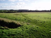
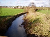
(3) River Rib
Other Links >>> |
|
THE HERTFORDSHIRE WAY - DAY 3
Thundridge to Much Hadham
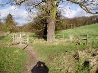
I did this walk on 21st January, just a couple of days after day 2. I parked my car in Ermine Street in Thundridge which is on the route of the Hertfordshire Way, just a few yards away from where I had finished my previous walk. The weather was quite breezy, but bright with plenty of sunshine and still feeling quite mild for the time of the year. Walking back up to the footpath that leads off to the left from Ermine Street I found it was still blocked by a tree that had fallen over in the gales earlier in the week but I managed to climb my way over without too much difficulty.
|
|
|
|
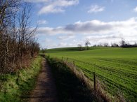
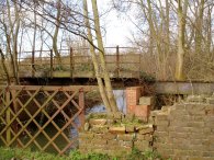
(1) Hertfordshire Way, Thundridge |
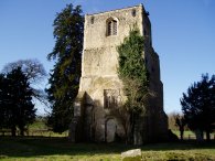
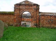
(2) Thundridge Old Church |
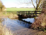
(3) River Rib |
This path leads down to a field and onto a track that takes the Hertfordshire Way under the new A10 Thundridge bypass. Having crossed underneath the road the route takes a footpath that runs off to the left along the bottom of a field, photo 1, towards the remains of Thundridge Old Church, photo 2. The path continues along past the church besides the field, crossing a track and enters another field this time running alongside the River Rib. At a ford, photo 3, the Hertfordshire Way crosses the route of the Harcamlow Way. This section of path was also used as a bridleway and thus was rather muddy.
 |
 |
 |
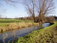
(4) River Rib |
(5) Buckney Wood |
(6) Path heading to Wareside |
The path continues alongside the River Rib, photo 4, before turning right onto a track that heads up a steep tree lined gully to a road. The path turns right along the road past some houses before taking a track that heads of to the left signposted to Sawtrees Farm. This passes through a rather muddy farmyard which had some building work going on and then bears right to follow the edge of a field gently uphill towards Buckney Wood, photo 5. The route heads into the woodland, skirting a reservoir. The path leaves the woodland on a tree lined track and runs besides a field before turning left down a track past Legges Cottage which runs downhill towards a road. The Hertfordshire Way then takes a foot path on the opposite side of the road, the path here being partially blocked by a giant trampoline that had blown out of a garden and was now propped up against a tree. Shortly after passing through a narrow bramble lines section of path the route bears left across a field, photo 6, and heads downhill to join a road which is followed for a short distance into the village of Wareside.
 |
 |
 |
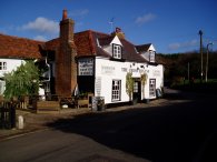
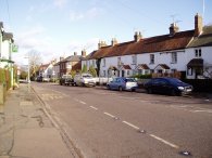
(7) Chequers Inn, Wareside |
(8) River Ash |
(9) Old Rail Bridge |
In Wareside the route heads left, past the Chequers Inn, photo 7, and along the road for a short distance to a footpath that runs diagonally off to the right besides a small stream. This leads down to a footbridge over the River Ash where the path turns right and runs bedsides the river, photo 8, up to the route of an old railway line. Crossing over a stile the route turns left to run along the side of a field parallel to the railway line. Climbing uphill and the downhill, the route passes into another field before taking a path that bears off to the left to run down to a road. The route then runs along the road for a short distance before taking track that heads into a field off to the left by the entrance of a garden centre, once again running alongside the route of the old railway. While most traces of the railway have been removed the crumbling remains of another bridge over the River Ash, photo 9, gave some idea of its construction with the steel supports and some sleepers still in place.
 |
 |
 |
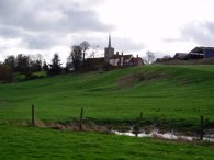
(10) St John the Baptists church, Widford |
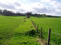
(11) Ash Valley, nr Widford |
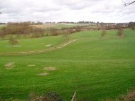
(12) View over the River Ash |
The route runs across fields with the church at St John the Baptists church, Widford, high on a ridge to the left, photo 10. Crossing a bridge over the River Ash the Hertfordshire Way turns right and starts heading back on itself on the other side of the valley, photo 11, as it gradually climbs uphill over a field back towards the church. This stretch of path marks the start of the Widford Loop of the Hertfordshire Way. The path climbs a flight of steps to enter the churchyard of St John the Baptists church, from where photo 12 was taken, looking back over the valley of the River Ash, the route of the Hertfordshire Way having crossed from left to right across the area in the photo before heading to where I currently was.
 |
 |
 |
(13) Churchyard, Widford |
(14) Widford |
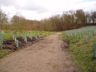
(15) Approaching Mill Wood |
Passing through the churchyard of St John the Baptists church the route turns left along the Abbots Lane to head into the village of Widford. In the churchyard was a separate enclosed burial area, reached through an attractive brick arch, photo 13. Reaching the centre of the Widford the Hertfordshire Way takes a footpath off to the left between houses just before the Green Man pub, photo 14. This heads down to a road, turning left briefly before taking another footpath off to the right between houses out of the village into a field that runs downhill back towards to the River Ash to complete the Widford Loop. Back at the River Ash once again, I turned right to continue my journey along the Hertfordshire Way towards Much Hadham. After passing between fields the path continues along a concrete track before skirting a water pumping station. At the end of a long field the path crosses a road into Bourne Lane. At Bourne Lodge the route turns left off the road along a track and a short distance further along takes the left hand fork in the path, photo 15, to head towards Mill Wood.
 |
 |
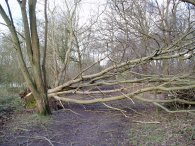
(16) Fallen tree, Mill Wood |
(17) Hertfordshire Way, nr Much Hadham |
The path runs through Mill Wood on a broad track. The path was once again obstructed in a number of places by fallen down trees, photo 16. The gales of the previous week were the strongest for 17 years in the South East and they had certainly found out the loose trees. Passing through Mill Wood the route reaches a point where the Hertfordshire Way heads in two directions. Ahead, the route continues on to Much Hadham where the Hertfordshire Way does another loop round before returning back to head off over the stile to the right of photo 17 to continue its journey round the County of Hertfordshire, it was here I finished my walk along the path for the day.
Altogether I had walked another 7.25 miles along the Hertfordshire Way to where I finished the walk, close to Much Hadham and a total of 12.8 miles for the day. Once again I wore my new Scarpa ZG65 XCR boots and once again they were completely comfortable.
![]() Back to:Walk index page
Back to:Walk index page
| ©2012 Bertuchi.co.uk. Please contact me using the email button on the right if you have any questions or comments regarding the site. Any feedback and additional information about places of interest on the walks is always welcomed. All rights reserved. Please contact me if you want to use any of the images or information from the site. ENJOY YOUR WALKING |
|