The Green Chain Walk
Other Links >>> |
|
THE GREEN CHAIN WALK - PART 2
Erith to Bostall Heath
|
|
The Green Chain Walk |
I did this walk on Sunday 9th January. I drove down to Erith where I parked in a small car park near the entrance to Erith Station which is free to park in on Sundays.
 |
 |
 |
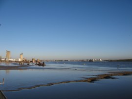
(1) River Thames, Erith |
(2) The start of stage 2 |
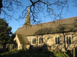
(3) St John the Baptists Church, Erith |
From my parking spot I walked down to the waterfront and then headed upstream along the Thames. Unlike my previous trip along the Green Chain Walk the weather was bright and sunny with not a cloud in the sky giving excellent views up and down the river, photo 1. The path runs alongside a number of fairly new housing estates that line the river in this area, before reaching the start point of the second stage of the Green Chain Walk, photo 2, at which point I had walked 0.58 of a mile from my parking place. The mudflats lining the Thames along the Erith water front where the resting place for numerous super market trolleys and I also spotted the remains of a wheelchair on the mud exposed by the relatively low tide at the time. Leaving the riverside the route heads inland along a path running behind houses to reach a road. Bearing right past the front of St John the Baptists Church, photo 3, the path then takes a green painted footbridge over the A 2016 road and rail lines as the path starts its journey towards Franks Park.
 |
 |
 |
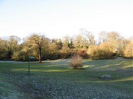
(4) Franks Park |
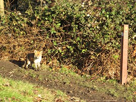
(5) Fox cub, Franks Park |
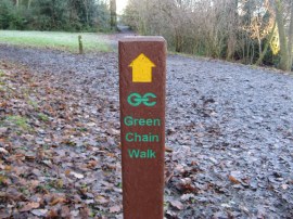
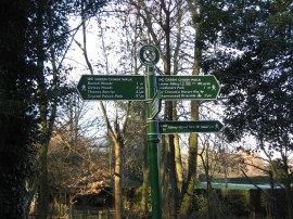
(6) Typical Green Chain Walk marker post |
Once over the footbridge the route continues ahead for a few yards up Pembroke Road before heading to the right along Valley Road, passing the entrance to a working men's club. Reaching the end of the road the route continues ahead along a broad, rather muddy track running through the trees of Franks Park, photo 3. Franks Park was originally part of the grounds of Belvedere House and is named after Frank Beadle whose wife provided the money in his memory for Erith Council to purchase the land in 1920. The route bears slightly to the left to reach an open grassy area where a fingerpost directs the route to the right across the frost covered grass into another band of the trees, the path steadily ascending opening up views over the Thames although the river itself remained hidden form view away to the right. Entering the trees I past close to a fox cub that had been standing on the path, photo 5, and as the route continues its way up along the well signed route, photo 6, along the lower edge of the park where I was passed by another obviously quite tame fox.
 |
 |
 |
(7) Lesnes Abbey Woods |
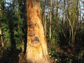
(8) Carved Tree |
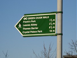
(9) The end point of stage 1 |
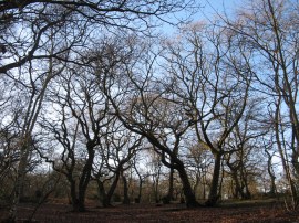
Leaving the park the route continues along the gently undulating Halt Robin Road before continuing ahead across Picardy Road into Upper Abbey Road. Reaching the end of the road the Green Chain Walk heads briefly to the right down St Augustines road near Ye Olde Leather Bottle pub before heading to the left along a track running besides garages. After a few yards the route bears to the left into another patch of woodland, Lesnes Abbey Woods, the route following a broad and well marked path that heads uphill through the trees. Reaching the top of the hill the route heads to the right across a more open, almost heath like area before joining a footpath that heads quite steeply back downhill through the woodland. One of the dead trees besides the path had been carved with a face which was something of a surprise when I came across it, photo 8. The route continues its course, heading up and down through the woodland and 2.5 miles after leaving the Erith waterfront I reached the point just above Lesnes Abbey which marks the end of stage one of the Green Chain Walk, photo 9, that I had visited the previous week.
 |
 |
 |
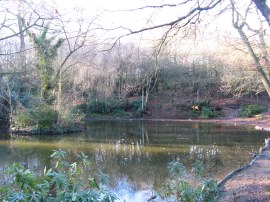
(10) Hurst Pond |
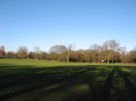
(11) Bostall Heath |
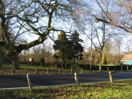
(12) Longleigh Lane |
Continuing ahead along stage two, the route crosses a road and once again heads uphill through more of the woodland along another damp and muddy path. Not far up the hill I passed a wooden bench which I noticed had a very misplaced way marker for the Capital Ring on one of its supports. Nearing the top of the hill the path heads to the right by a small pond enclosed by a metal fence, photo 10. A short distance further on the path reaches a Hurst Road where the route heads to the right for a few yards before heading up to the left along a road running through a small housing estate. The route follows the road to the right through the housing estate before crossing over the top end of Knee Hill to join a track continuing ahead that leads into Bostall Woods. The route soon joins another track on the left that is followed up to the A206 Bostall Hill Road where the Green Chain Walk bears right heading across the road to run along the left hand edge of the wide open space of Bostall Heath, photo 11. The path is followed around the edge of the trees to reach Longleigh Lane, photo 12, by a small car park and play area which marks the end of the second stage of the Green Chain Walk.
This point also marks the start of stage 3 which bears off to the left through the trees on the other side of the road as well as the end point of stage 4a which arrives at this point from Charlton Park. As ever this stage of the route had been impeccably way marked with a wide range of differing sign posts and information boards. My GPS said 3.98 miles when I reached Longleigh Lane which meant it made the length of stage two 3.4 miles from Erith Waterfront.
Having completed stage two I then set off along stage 3 of the walk which runs down to Oxleas Meadows.
I have uploaded the route of the walk which can be accessed here Green Chain Walk Section 2 Route.
If you would like to comment on this walk you can do so here:
![]() Back to:Walk Index Page
Back to:Walk Index Page
| ©2012 Bertuchi.co.uk. Please contact me using the email button on the right if you have any questions or comments regarding the site. Any feedback and additional information about places of interest on the walks is always welcomed. All rights reserved. Please contact me if you want to use any of the images or information from the site. ENJOY YOUR WALKING |
|