Chiltern Way
Other Links >>> |
|
CHILTERN WAY - Part 11
Chalton to Warden Hill
|
|
Chiltern Way |
I did this walk on Sunday 18th November. It was a glorious bright sunny day without a cloud in the sky, with the air nice and still although a little chilly, the car thermometer showing only 3c when I parked up in the village of Chalton and there was still a heavy frost on the ground in any shaded areas.
 |
 |
 |
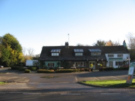
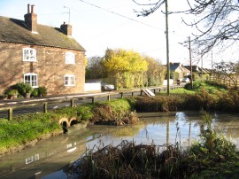
(1) Star Pub, Chalton |
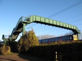
(2) Footbridge over the railway |
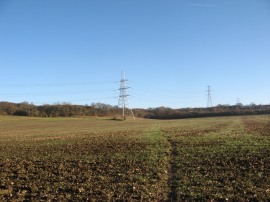
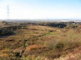
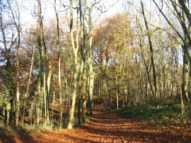
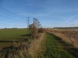
(3) Chiltern Way nr Chalton |
From my parking spot in Chalton Heights it was just a short walk down the B579 Luton Road to rejoin the Chiltern Way, opposite the Star Pub, photo 1. The route heads through the pub car park to join a footpath which heads through a small area of scrubby ground before soon joining a track that leads round to a concrete bridge over the M1 motorway. Once over the motorway the track curves round to the left and soon reaches a large, green painted footbridge, photo 2, which carries the route across the main line railway from where there were views across to the nearby Sundon Electricity sub-station and its radiating cluster of electricty pylons. From the railway bridge the Chiltern Way then heads across the middle of a couple of fields, heading gently uphill towards some electricity pylons, photo 3, and into a small area of trees.
 |
 |
 |
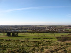
(4) View back towards Chalton |
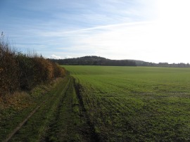
(5) Path leaving Sundon |
(6) Sheep grazing on the Sundon Hills |
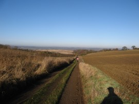
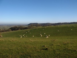
Here the route continues ahead across a broad track and on uphill through a band of trees. Nearing the top of the hill the Chiltern Way joins a footpath that bears slightly to the right to run along the right hand edge of a hedge. This path continues more gently uphill alongside an area of scrubby open ground with the electricity pylons running away to the right. Reaching a kissing gate in the hedge the route bears briefly to the left, heading downhill before climbing uphill along a flight of steps near the outskirts of Sundon. Coming in the opposite direction where a large number of people walking or running, following route directions that they were all carrying ,and I would keep coming across more of them over the next mile or so although they weren't strictly following the Chiltern Way but heading on and off the path on a far more circuitous route round the Sundon area. At the top of the steps, photo 4, from where there were good views back over the surrounding countryside, the route crossed a track and then headed over the middle of a small field up to the houses in Sundon. This field had been recently ploughed and my boots were soon caked in mud although luckily the field was not that big and it was the only field like it that I encountered all day. Leaving the muddy field the route crosses a minor road and continues along an alleyway running between houses. Leaving this the path follows the road ahead, heading slightly to the right to join a footpath running along the right hand edge of some playing fields. The Chiltern Way then heads to the left along the bottom edge of the playing fields up to Harlington Road, opposite a pub. Crossing this road the Chiltern Way continues ahead along a broad track which leads out to open fields, photo 5, the path heading downhill towards a sewage works. Here the route bears to the right, heading along the bottom edge of some open ground. Reaching some trees the route heads sharp right heading back uphill along the edge of the open ground before turning to the left to join a footpath running along the top of a ridge with fine views off to the left over the Bedfordshire countryside although the peaceful scene was somewhat disturbed by the noise coming up from the nearby M1 motorway. Reaching the end of this long stretch of path the route heads to the right up the Harlington Road for a short distance before turning to the left to join another footpath. This crosses over a small field and then heads once again along a field edge path running alongside a large open area of grassland belonging to the National Trust which was being grazed by a flock of sheep, photo 6.
 |
 |
 |
(7) Walk way markers |
(8) Beech Trees, Sharpenhoe Clappers |
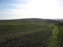
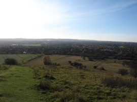
(9) View towards Barton |
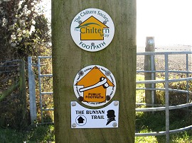
There were still excellent views across the surrounding countryside and I found the whole area far more pleasant and attractive to walk through than I had imagined when looking at the route on the map. For some time I had been following the route of the Icknield Way and I had now also linked up with the route of the John Bunyan Walk, photo 7. After a while the Chiltern Way heads off to the right along the edge of another large open field across the top of the hill before heading to the left to continue in a generally easterly direction along the top of the ridge. For a while the route heads through a narrow stand of tall old Beech trees, their copper coloured leaves lying thick on the ground, before joining another field edge path running along the top of the ridge. This heads across a field to reach the Sharpenhoe Road where the Chiltern Way continues ahead through a car park and along a track before bearing to the left along a track that runs through an area of woodland. Reaching an open area the route continues ahead into an area of Beech trees on the Sharpenhoe Clappers at the site of an old Iron Age Fort, photo 8. Here I went slightly, and rather annoyingly, off course. The correct route of the Chiltern Way continues ahead passing downhill along the left hand side of the fort where the path heads down towards the village of Sharpenhoe and also to the point where the Northern extension of the Chiltern Way leaves the main route. I however turned to the right along a path running along the top edge of the beech trees. Very soon I linked back up with the main path on its way back up from the bottom of the hill which I then followed off to the right to join a path running between the fields and grassland and the top of Sharpenhoe Clappers and it was only when I had walked a fair distance down this path that I realised I had cut a rather large corner off the route which, for the sake of completeness, I will have to walk when I start the Northern extension! Reaching a kissing gate the route bears to the left across a grassy area on top of the hill before joining an enclosed path running alongside the edge of fields. Once again there were good views across surrounding countryside, this time over the village of Barton, photo 9 towards Cambridgeshire and I stopped and had a chat with some National Trust workers who were clearing scrub from the grassland who pointed out some of the features of the surrounding landscape.
 |
 |
 |
(10) Path along the Sharpenhoe Clappers |
(11) St Margaret's Church, Streatley |
(12) Streatley pond |
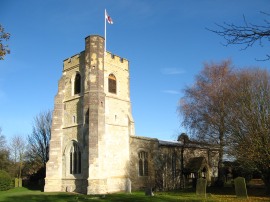
The path, photo 10, then winds its way round the top this upland area as the Chiltern Way heads over to the village of Streatley, gradually heading downhill by the A6 to reach Church Road. Here the route heads to the right up to the centre of the village. Reaching a T junction the route heads briefly to the left before heading up to the right into the churchyard of St Margaret's church, photo 11. The Luton Marathon was taking place and there was a drinks stand on the road and a steady stream of runners making their way by. I myself had a short snack stop in the churchyard before heading on along a footpath running between houses which leads out to fields. This path soon curves road back to join the Sharpenhoe Road by Streatley pond, photo 12, where the Chiltern Way heads along down the road to the busy A6 road where I had a little wait for a suitable gap in the traffic to cross the road.
 |
 |
 |
(13) Path from the A6 nr Streatley |
(14) Heading towards Galley Hill |
(15) Crossing Galley Hill |
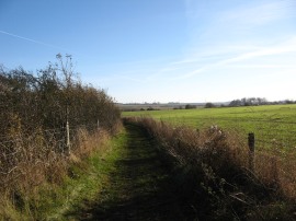
Once over the road the route continues ahead along a broad green footpath past the Swedish Cottageswith large open fields on either side of the path from where there were good views across to Galley Hill and Warden Hill on the right, which was to be my destination for the days walk. This stretch of path is also running parallel to a long line of electricity pylons which had been a feature in the landscape for much of this stage, photo 13. There was a Buzzard soaring around in the clear skies overhead although I did not see any of the Red Kites that were often about on the earlier stages of the walk further south. This long straight of path eventually leads to a junction of paths under the electricity pylons where the Chiltern Way heads to the right with the Galley Hill ahead on the horizon, photo 14. At the end of the field the route heads uphill through a small area of woodland, where there was also an information board detailing the route of the Icknield Way through the area, before bearing to the right across one of the fairways of the South Beds golf course. This soon leads to a grass covered path that heads up towards the top of Galley Hill. Heading over Galley Hill, photo 15, the route turns to the left at a kissing gate to continue on along the top edge of the hill, following a fence round to join a chalky track. Here the route heads briefly to the right before once again joining another footpath on the left that heads up the grassy flanks of Warden Hill.
 |
 |
 |
(16) View towards Leagrave |
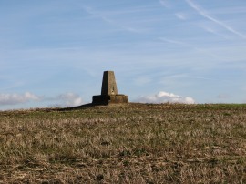
(17) Trig point on Warden Hill |
(18) The end point of this stage |
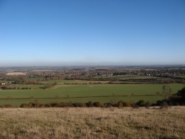
Once again there were good views over the surrounding countryside towards Luton and Leagrave, photo 16, and the footpath that runs round the edge of the urban area which I would soon be following on my way back to Chalton. Heading across the top of the hill I made a short detour over to the trig point, photo 17, where I stopped for a short break before following the Chiltern Way to the end of the hill where I finished this stage of my walk along the Chiltern Way having walked a further 9.8 miles along the path, again this was a bit more than the distance as suggested in the guidebook, particularly as I had cut off the corner at Sharpenhoe Clappers. The route of the Chiltern Way off the hill was a bit uncertain however I continued ahead to the foot of the hill before heading off to my right towards the edge of Leagrave to start my journey back to the car.
 |
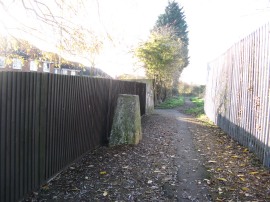 |
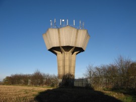
(19) Marsh Farm Water Tower |
(20) Trig point 11424 |
I followed a path that run along the edge of the South Beds golf course before heading to the left along a path known as the Theedd Way Trail which follows the buildings on the edge of Luton. This path runs for some distance, with houses to the left an open ground on the right. About half way to Sundon Park the path passes besides a water tower at Marsh Farm, photo 19,which had been visible for some time during my actual walk along the Chiltern Way. Close to the water tower, now embeded in the footpath was a trig point, 11424, photo 20. The footpath continued on to reach a road at Sundon Park where I continued ahead along Camford Way, which runs alongside an industrial estate before joining a field edge path on the left which curves round to the Sundon Road. Here I headed to the left, crossing over the railway lines, before heading to the right along the B579 Luton Road which I followed over the M1 motorway and back to my parking spot in Chalton.
As usual I have uploaded the route of the walk which can be accessed here: Chiltern Way Stage 11 Route.
Reaching the car I had walked a total distance of 14.4 miles. I had enjoyed this walk and the scenery was far better than I was expecting from this area. My only regret is missing off the chunk of path at Sharpenhoe however that can be walked another day.
![]() Back to:Walk index page
Back to:Walk index page
| ©2012 Bertuchi.co.uk. Please contact me using the email button on the right if you have any questions or comments regarding the site. Any feedback and additional information about places of interest on the walks is always welcomed. All rights reserved. Please contact me if you want to use any of the images or information from the site. ENJOY YOUR WALKING |
|